Saint-Laurent-sur-Mer in Calvados, Normandy, France — Western Europe
Omaha la Sanglante - Bloody Omaha
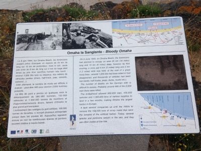
Le 6 Juin 1944, sur Omaha Beach, les Américains avaient prévu d'occuper une espace 25 km (16 miles) de long sur 10 km (6 miles) de profondeur, mais le soir, seule une zone de 8 km de long sur 2 km de large était tenue au prix d'un sacrifice humain très lourd : environ 1 200 GIs tués ou disparus, des milliers de véhicules perdus (chars, half-track, jeep, canards, camions…).
Côté allemand, le nombre de morts est difficile à évaluer : peut-être 400 pour environ 2 000 hommes présents.
La tête de pont a permis en quelques mois le débarquement de 500 000 hommes, 100 000 véhicules et 1 300 000 tonnes de munitions et d'approvisionnements divers, faisant d'Omaha le plus grand port européen.
L'enlèvement des vestiges du port artificiel, 150 000 tonnes de ferrailles, a occupé plusieurs entreprises jusque dans les années 50. Aujourd'hui reposent encore en mer de nombreuses épaves et pontons souvent visibles à marée basse.
On 6 June 1944, on Omaha Beach, the Americans had planned to occupy an area 25 km (16 miles) long and 10 km (6 miles) deep, however by that evening, a zone just 8 km (5 miles) long and 2 km (1.2 miles) wide was held, at the cost of a great many lives : around 1,200 GIs had been killed or had disappeared, and thousands of vehicles had been lost (tanks, half-tracks, jeeps, ducks, trucks etc.).
The number of deaths on the German side is difficult to assess. Probably around 400 of the 2,000 men there were killed.
The bridgehead allowed 500,000 men, 100,000 vehicles and 1,300,000 tons of various supplies to land in a few months, making Omaha the largest harbor in Europe.
It took several companies up until the 1950s to remove the 150,000 tons of scrap metal that were the remains of the artificial harbor. Today, several wrecks and pontoons remain in the sea, and they are often visible at low tide.
Erected by Normandie Terre de Liberté.
Topics and series. This memorial is listed in this topic list: War, World II. In addition, it is included in the Lost at Sea series list. A significant historical date for this entry is June 6, 1944.
Location. 49° 22.095′ N, 0° 52.274′ W. Marker is in Saint-Laurent-sur-Mer, Normandie (Normandy), in Calvados. Memorial is on Rue Bernard Anquetil, on the left when traveling east. Touch for map. Marker is in this post office area: Saint-Laurent-sur-Mer, Normandie 14710, France. Touch for directions.
Other nearby markers. At least 8 other markers are within 3 kilometers of this marker, measured as the crow
flies. Omaha Beach, haut lieu du Débarquement du 6 juin 1944 (approx. 0.6 kilometers away); Les Braves - To Those Brave Men (approx. 0.7 kilometers away); Remember Omaha (approx. 0.7 kilometers away); a different marker also named Omaha Beach (approx. 0.7 kilometers away); Operation Aquatint (approx. 0.8 kilometers away); General Dwight D. Eisenhower (approx. 1.6 kilometers away);
Additional keywords. Omaha la Sanglante
Credits. This page was last revised on September 10, 2018. It was originally submitted on July 22, 2015, by Kevin W. of Stafford, Virginia. This page has been viewed 349 times since then and 18 times this year. Photos: 1, 2. submitted on July 22, 2015, by Kevin W. of Stafford, Virginia.

