Near Bessemer Bend in Natrona County, Wyoming — The American West (Mountains)
Queen City of the West

Photographed By Barry Swackhamer, September 17, 2015
1. Queen City of the West Marker
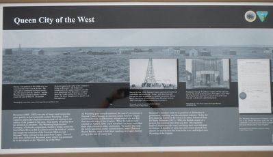
Captions: (upper left) Shining with optimism in this 1890 view, two years later Bessemer was in decline. The railroad had terminated in Casper, nearby oil wells turned out to be "dusters," and the Wyoming Improvement Company owed the county the sum of $265.78 - an amount equal to the value of the company's bridge at Bessemer. The bridge was transferred to the county treasurer, oil wells were abandoned, and Bessemer's residents moved to Casper, taking their houses with them. The town disappeared as quickly as it had appeared.; Inserts: (left) During the late 1880s Natrona County experienced its first oil exploration and production "boom," with American and foreign investors scrambling to establish operations. Shown here is one of two oil wells drilled near Bessemer town in 1888, with eager citizens monitoring its progress.; (center) Postmaster George W. Johnson stands with his wife and son on the porch of the Bessemer Post Office, circa 1892. Mr. Johnson also operated a general store in the town. Note the well derrick, right background.; (right) The Wyoming Improvement Company sold lots in the platted Bessemer town site, but confidently reserved an entire block on their plat map with the label "State Capitol."
As Wyoming grew toward statehood, the seat of government in Natrona County became an election contest between Casper, twelve miles east, and Bessemer, whose platted site was less than one mile west of this location. When the ballots were counted on April 8, 1890, each town had cast more votes than there were citizens in either community. To resolve the issue, the newly appointed county commissioners, under Chairman Bryant Brooks, voted to hold their meetings in Casper, thereby giving it the title of County seat.
Bessemer's founders went on to positions of distinction in government, ranching, and the petroleum industry. Today the only enduring feature of the town is its name, borrowed from Sir Henry Bessemer (1813-1898), the British creator of a process that rendered steel from pig iron. His ingenuity inspired Americans who were sustaining their own industrial revolution. A handful of such men and women planted their dreams for a while near this bend in the river, and helped raise Wyoming in the bargain.
Erected by Department of the Interior, Bureau of Land Management.
Topics. This historical marker is listed in this topic list: Settlements & Settlers.
Location. 42° 46.423′ N, 106° 31.823′ W. Marker is near Bessemer Bend, Wyoming, in Natrona County. Marker is on Bessemer Bend Road (Route 308) near Speas Road (Route 311), on the right when traveling east. Touch for map. Marker is at or near this postal address: 14456 Bessemer Bend Road, Casper WY 82604, United States of America. Touch for directions.
Other nearby markers. At least 8 other markers are within walking distance of this marker. "History Is Not Obvious" (a few steps from this marker); Ranching Takes Its Place (a few steps from this marker); Red Buttes (within shouting distance of this marker); Shape of the Future (within shouting distance of this marker); Witnessing the Past (within shouting distance of this marker); Science Visits the West (within shouting distance of this marker); Marking Their Progress
(within shouting distance of this marker); Reluctant Farewells (within shouting distance of this marker). Touch for a list and map of all markers in Bessemer Bend.
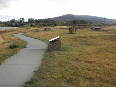
More about this marker. This marker is located at the Bureau of Land Management's Bessemer Bend Historic Site.
Credits. This page was last revised on June 16, 2016. It was originally submitted on January 2, 2016, by Barry Swackhamer of Brentwood, California. This page has been viewed 336 times since then and 13 times this year. Photos: 1, 2. submitted on January 2, 2016, by Barry Swackhamer of Brentwood, California.
