Near Hollister in Santa Clara County, California — The American West (Pacific Coastal)
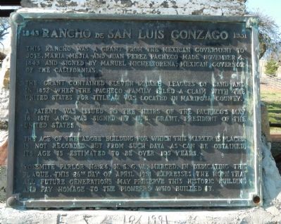
1843 - Rancho de San Luis Gonzaga - 1931
The grant contained eleven square leagues of land and in 1852 when the Pacheco family filed claim with the United States for title it was located in Mariposa County.
A patent was issued to the heirs of the Pacheco’s May 16, 1871 and was signed by U.S. Grant, President of the United States.
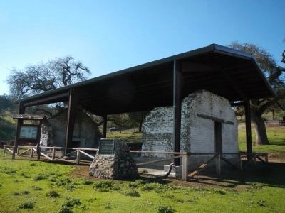
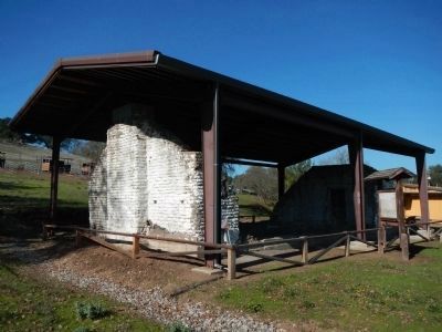
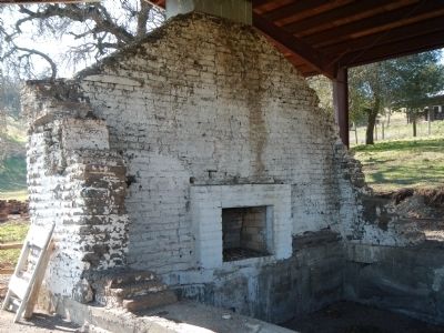
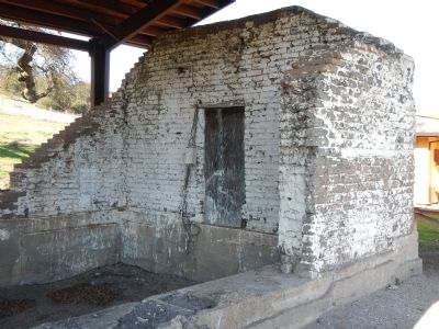
The age of the “adobe” building for which this marker is placed is not recorded, but from such data as can be obtained its age is estimated to be over 105 years.
Yosemite Parlor No. 24, N.S.G.W., Merced, in dedicating this plaque, this 26th day of April 1931 expresses the hope that all future generations may preserve this historic building and pay homage to the pioneers who built it.
Erected 1931 by Native Sons of the Golden West, Yosemite Parlor No. 24.
Topics and series. This historical marker is listed in this topic list: Settlements & Settlers. In addition, it is included in the Former U.S. Presidents: #18 Ulysses S. Grant, and the Native Sons/Daughters of the Golden West series lists. A significant historical month for this entry is April 1931.
Location. 37° 3.609′ N, 121° 13.27′ W. Marker is near Hollister, California, in Santa Clara County. Marker can be reached from Whiskey Flat Road/Trail. These markers are located in Pacheco State Park. Whiskey Flat Road is unsigned on Highway 152. The road is gated and locked at the picnic grounds and you must walk 1/4-mile to the employee residences where the adobe is located. Touch for map. Marker is in this post office area: Hollister CA 95023, United States of America. Touch for directions.
Other nearby markers. At least 8 other markers are within 9 miles of this marker, measured as the crow flies. The Old Adobe of Rancho San Luis Gonzaga (here, next to this marker); Bell Station (approx. 5.2 miles away); Pacheco Pass (approx. 6.9 miles away); First Marine Division – FMF (approx. 8.7 miles away); Remember Pearl Harbor (approx. 8.7 miles away); The Remembrance Memorial for California Korean War Veterans (approx. 8.7 miles away); In Memory of Korean War Veterans (approx. 8.7 miles away); The Chosin Few (approx. 8.7 miles away).
Regarding 1843 - Rancho de San Luis Gonzaga - 1931. "The history of Pacheco State Park begins with its strategic location at the edge of the Diablo Range, providing a crucial transportation link between the Pacific coast and California's Central Valley. In 1806 Gabriel Moraga and Father Pedro Munoz traversed the pass during the first documented European
expedition. Pacheco State Park was originally part of El Rancho San Luis Gonzaga, a 50,000 acre Mexican land grant given in 1843 to Juan Pacheco, son of Francisco Pacheco, a Spanish soldier and wagon maker who came to California with nothing in 1821. By 1850, Pacheco, the wealthiest landowner in Monterey County, owned 150,000 acres. The flourishing Pacheco family continued to increase their land holdings and maintain title to their property for five generations.
Around 1844, Pacheco constructed the area's first adobe building near the location where Moraga and Munoz had camped nearly 40 years earlier. The new adobe house subsequently served as a stage stop, telegraph station, gambling hall and even a gas station and roadside cafe for travelers until 1962. Many roads have been built through the tranquil hills, including the original Pacheco Pass toll road, engineered by Andrew Firebaugh in 1856. The park came into existence through the dream of Paula Fatjo, the great-great granddaughter of Francisco Pacheco. After inheriting the land, Fatjo wanted her ranch to be safeguarded for those who shared her love of the animals and the beautiful unspoiled and found here. In 1992, she donated the remaining 6,890 acres of Pacheco property to the State." - Source: Pacheco State Park brochure.
Additional keywords.
1843 - Rancho de San Luis Gonzaga - 1931 | 1843 - Rancho de San Luis Gonzaga - 1931
Credits. This page was last revised on August 19, 2023. It was originally submitted on February 5, 2013, by Barry Swackhamer of Brentwood, California. This page has been viewed 1,182 times since then and 67 times this year. Last updated on July 28, 2023, by Ronald D. (Ron) Trigueiro of Fresno, California. Photos: 1, 2, 3, 4, 5. submitted on February 5, 2013, by Barry Swackhamer of Brentwood, California. • Bill Pfingsten was the editor who published this page.
