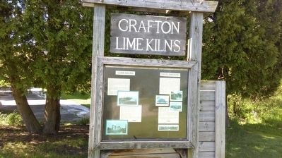
Grafton Lime Kilns
Lime Kilns
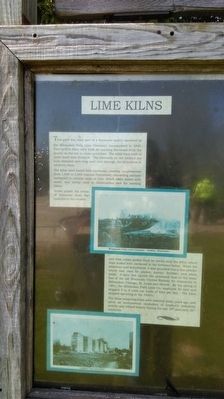
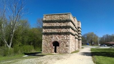
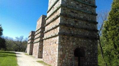
This park was once part of a limestone quarry operated by the Milwaukee Falls Lime Company, incorporated in 1890. Five vertical kilns were built for burning limestone from the quarry on the site to make quicklime. The kilns were built of stone lined with firebrick. The fasteners on the timbers are nuts threaded onto long steel rods through the structures to reinforce them.
The kilns were fueled with cordwood, creating temperatures from 1,400 to 2,000 degrees Fahrenheit, converting calcium carbonate to calcium oxide or lime, which when mixed with water, was widely used in construction and for tanning hides.
Mules pulled the trams of limestone from the quarries to the crusher, and then cables pulled them on tracks atop the kilns, which were stoked with cordwood in the fireboxes below. When the limestone was dehydrated, it was pounded into a fine powder which was used for plaster, mortar, fertilizer, and white wash. A spur line carried the processed lime to the main line of the old Wisconsin Central Railway for shipments to Milwaukee, Chicago, St. Louis and Detroit. By the spring of 1901, the Milwaukee Falls Lime Co. employed 50 men and shipped 5 to 6 train car loads of lime per day. The kilns stopped operating in the 1920's.
The three remaining kilns were restored many years ago, and serve as monumental
reminders of Grafton's industrial activity and related history during the late 19th and early 20th centuries.
Iron Bridge
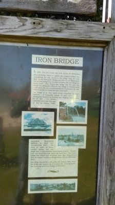
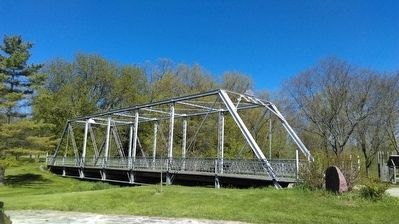
In 1888, this iron bridge was built across the Milwaukee River at Bridge Street to replace the original wooden one, maintaining the only access to the village from the east. Built by the Wisconsin Bridge and Iron Co. of Wauwatosa, the old iron bridge was the main entrance into the Village for many years. This riveted iron bridge was the only way across the Milwaukee River in the Village of Grafton until 1928 when the new concrete bridge on Washington St. was built to handle increased car and truck traffic.
The bridge is an iron truss bridge comprised of seven modules - a triangular module on each end and five rectangular modules in between with diagonal tension rods in all five. The riveted assembly has a cast iron sign at the top reading "1888 BUILDERS WISCONSIN BRIDGE & IRON CO. WAUWATOSA WIS." The deck is made of heavy wooden planks and was single lane to accommodate horse-drawn wagons. Tension rods run along each side below the deck level. The entire bridge was coated with aluminum paint after being moved from its original location on Bridge Street over the Milwaukee River.
The bridge was moved to the Lime Kiln Park in 1996, when the bridge was replaced by a concrete one. It is one of the few remaining steel truss bridges in Wisconsin.
Topics. This historical marker is listed in these topic lists: Bridges & Viaducts • Industry & Commerce.
Location. 43° 18.32′ N, 87° 57.336′ W. Marker is in Grafton, Wisconsin, in Ozaukee County. Marker can be reached from Green Bay Road. Touch for map. Marker is in this post office area: Grafton WI 53024, United States of America. Touch for directions.
Other nearby markers. At least 8 other markers are within 2 miles of this marker, measured as the crow flies. Lime Kiln Dam (about 500 feet away, measured in a direct line); Lime Kiln Dam Removal (about 500 feet away); Chair Factory History (approx. 0.3 miles away); The Blues Trail: Paramount Records (approx. 0.4 miles away); Paramount Records Legacy (approx. 0.9 miles away); Welcome to the Grafton Riverwalk (approx. 1.1 miles away); Concordia Mill (approx. 1.6 miles away); Origin of Cedar Creek / Mills on the Creek (approx. 1.6 miles away). Touch for a list and map of all markers in Grafton.
More about this marker. The marker is located in Lime Kiln Park in between the lime kilns and iron bridge.
Credits. This page was last revised on June 21, 2016. It was originally submitted on June 13, 2016, by Devon Polzar of Port Washington, Wisconsin. This page has been viewed 677 times since then and 78 times this year. Photos: 1, 2, 3, 4, 5, 6. submitted on June 13, 2016, by Devon Polzar of Port Washington, Wisconsin. • Bill Pfingsten was the editor who published this page.
