Near Buford in Lancaster County, South Carolina — The American South (South Atlantic)
Disaster in South Carolina
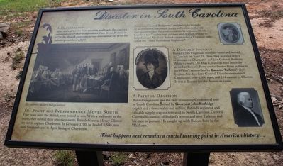
After years of tension over taxation and trade, the America colonies declared their independence from Great Britain in 1776. The British Government was determined not to let the colonies go without a fight.
The Fight for Independence Moves South
Four years later the British were poised to win. With a stalemate in the north, British General Henry Clinton set out to capture Charleston. In February 1780, he landed 8,500 men near Savannah and in April besieged Charleston.
American General Benjamin Lincoln (right) brought in all available Continental troops and militia to the city and urgently asked for reinforcements. In response, North Carolina and Virginia sent veterans and drafted citizens to help. Colonel Abraham Buford commanded a Virginian unit, called the "Third Provisional Regiment."
A Doomed Journey
Buford's 350 Virginians marched south and arrived at Camden on April 25. Here, they received orders to proceed to Charleston and join Colonel Anthony White's cavalry. On May 6, Buford's men belatedly arrived at Lenud's Ferry on the Santee River in time to see White's destruction by Banastre Tarleton's (left) Legion. Six days later General Lincoln surrendered Charleston, over 6,000 men, and 154 cannon to Clinton. It was a disaster for the American cause.
A Fateful Decision
Buford's regiment was the only remaining Continental unit in South Carolina. Joined by Governor John Rutledge (right) and a few cavalry and militia, Buford's regiment and valuable supply wagons retreated to North Carolina. General Cornwallis learned of Buford's retreat and sent Tarleton and his men in pursuit. He caught up with Buford here in the Waxhaws.
What happens next remains a crucial turning point in American history …
Topics. This historical marker is listed in this topic list: War, US Revolutionary. A significant historical date for this entry is May 29, 1780.
Location. 34° 44.516′ N, 80° 37.567′ W. Marker is near Buford, South Carolina, in Lancaster County. Marker can be reached from Rocky River Road (State Highway 522) 0.2 miles south of Pageland Highway (State Highway 9), on the right when traveling south. This marker is located at the Buford Battleground Monument Park (Buford Massacre Site). Touch for map. Marker is in this post office area: Lancaster SC 29720, United States of America. Touch for directions.
Other nearby markers. At least 8 other markers are within walking distance of this marker. Buford Battleground (here, next to this marker); Buford's Defeat (here, next to this marker); Battle of the Waxhaws: Massacre or Myth? (a few steps from this marker); Buford's Massacre (a few steps from this marker); Memorials and Archaeology
(a few steps from this marker); Honoring The Fallen (within shouting distance of this marker); Buford Monument (within shouting distance of this marker); Buford's Bloody Battleground (approx. 0.2 miles away). Touch for a list and map of all markers in Buford.
More about this marker. The is the first of four markers that interpret Buford's Massacre and preservation of the site.
Regarding Disaster in South Carolina. Image on the left side: "The colonies declare independence." As indicated in the text, portraits of General Benjamin Lincoln, Colonel Banastre Tarleton and Governor John Rutledge are seen on the right.
Additional keywords. massacre
Credits. This page was last revised on July 1, 2016. It was originally submitted on July 1, 2016, by David Graff of Halifax, Nova Scotia. This page has been viewed 535 times since then and 20 times this year. Photos: 1, 2. submitted on July 1, 2016, by David Graff of Halifax, Nova Scotia.

