Near Kirk Road, 1.6 kilometers north of Route A85, on the left when traveling north.
Cala air Falach
A Hidden Haven
The castle and its peninsula still shelter Dunstaffnage Bay from the worst of the westerly winds. They also hid moored vessels from the view of potential attackers.
Tides of Fortune
For several . . . — — Map (db m127407) HM
Near Kirk Road, 1.6 kilometers Route A85, on the left when traveling north.
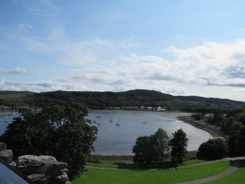
Sealladh Àrd
A Towering Outlook
The superb strategic location of the castle within a network of coastal strongholds, gave it panoramic views in all directions. No vessel — or marching army — could approach Dunstaffnage without . . . — — Map (db m127411) HM
Near Kirk Road, 1.6 kilometers north of A85, on the left when traveling north.
Air cùl Bhallachan
Behind the Walls
You can see how these high walls and the single entrance made the castle safe. Its life as a private residence lasted until 1888, when most of its buildings were in ruins.
Changing Times, Changing . . . — — Map (db m127409) HM
Near Kirk Road, 1.6 kilometers north of Route A85, on the left when traveling north.
Cridhe a’ Chasteil
Core of the Castle
This courtyard was the heart of a busy, well-defended community. At one time, there was a drawbridge to stop uninvited visitors from getting in.
A Safe Shelter
The castle in the early . . . — — Map (db m127406) HM
Near Kirk Road, 1.6 kilometers north of Route A85, on the left when traveling north.
Fàilte do Chaisteal Dhùn Staidhinis
Welcome to Dunstaffnage Castle
Duncan MacDougall built this fortress as a statement of his status as Lord of Lorn. It is one of Scotland's oldest stone castles and guards the approaches to Loch Etive. . . . — — Map (db m127402) HM
On Route A85 at Lora Falls Bridge (Route A828), on the right when traveling south on Route A85.
Falls of Lora
At certain states of the tide you will see spectacular overfalls with a water level drop of up to 1.2m and a lot of white water in front of you. The Falls of Lora form at the shallow narrows where Loch Etive in the east meets the open . . . — — Map (db m127537) HM
On Station Road at Shore Street, on the right when traveling south on Station Road.
Tilleadh Guiseppe Alba, 2009
Chuir Comhairle Earra-Ghàidheal agus Bhòid agus muinntir an Obain
Fàilte air a h-uile duine a thàinig dhachaigh Samuel bhliadhna shònraichte seo.
Am Mòd Nàiseanta Rìoghail, an t-Òban 2009
Creathall . . . — — Map (db m127368) HM
Near Kirk Road, 1.6 kilometers north of Route A85, on the left when traveling north.
Ceartas is Cuirmean
Justice and Joviality
The great hall occupied the whole floor above you. It was the hub of the castle, where the Lord of Lorn sat in banquets in the evening.
Gone is the Grandeur
The great hall was part of . . . — — Map (db m127405) HM
On Albany Street at Shore Street, on the right when traveling north on Albany Street.
Robert Barbour
McKelvie, M.D.
Medical Officer
to the Parishes
of Lismore and Appin
1860 – 1875
Kilmore
and
Kilbridge
1875 – 1901
“A Man He Was To All
The Country Dear”
Erected by His . . . — — Map (db m127365) HM
On Station Road at Shore Street, on the right when traveling south on Station Road.
Oban
The Burgh of Oban
Established by
Charter of resignation novodamus
and erection under the Great Seal -17th July 1811
Bicentenary commemoration -12th July 2011
The Princess Royal unveiled this commemorative plaque
at the behest of . . . — — Map (db m127367) HM
On George Street at Stafford Street, on the left when traveling north on George Street.
Uisge Beatha
The Water of Life
Atlantic Ocean Weather Systems Play a Considerable Part
In Life on Scotland’s West Coast and Bring
The Water of Life to All Who Live Here
It comes from the sea · It comes from the sky · It comes . . . — — Map (db m127538) HM
Near Kirk Road, 1.6 kilometers north of Route A85, on the left when traveling north.
Air Faire
Watching, Waiting and Warning
Soldiers on the wall walk scanned sea and land for enemy attacks and alerted their officers in the guard room above you.
Firing Through Fishtails
When the castle was built, arrow slits . . . — — Map (db m127412) HM