On SE Monroe Street south of SE 15th Street, on the left when traveling south.
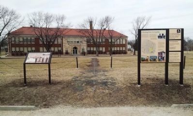
Across the field in front of you stands the former Monroe Elementary School. Parents of six students that attended this school in 1949 participated in the Brown v. Board of Education lawsuit. On May 17, 1954, the US Supreme Court issued a . . . — — Map (db m81395) HM
On SE Monroe Street south of SE 15th Street, on the left when traveling south.
When Monroe Elementary School opened in 1927, it was a key part of Topeka's grand, million-dollar school construction program. Topeka wanted a first-class educational system that would promote pride in the city's schools. The new Monroe School . . . — — Map (db m81392) HM
On SE Monroe Street south of SE 15th Street, on the right when traveling south.
The Topeka chapter of the National Association for the Advancement of Colored People (NAACP) recruited 13 African American parents to file a lawsuit contesting the state law that allowed cities like Topeka to segregate students in elementary . . . — — Map (db m81393) HM
On Martin Luther King Jr. Avenue Southeast at Stanton Road Southeast, on the right when traveling north on Martin Luther King Jr. Avenue Southeast.
Campbell AME, established in 1867 as Mount Zion AME, was an outgrowth of its overcrowded parent church, Allen Chapel AME, founded in 1850. When it moved to a location near the present one in 1890, Mount Zion was renamed for AME Bishop Jabez B. . . . — — Map (db m33749) HM
On King Street at Fifth Street, on the left when traveling south on King Street.
Delaware remained a racially segregated society until the mid-twentieth century. Though the segregation of public schools was supported by the “separate but equal” doctrine that had been upheld by the nation’s highest court, the facilities and . . . — — Map (db m165893) HM
On Dinkins Street near Grace Street, on the right when traveling west.
(Front text)
This church was founded about 1869 by Mary Scott “Aunt Mary” Harvin, and held its first services in a nearby brush arbor. In 1881 church trustees purchased a one-half acre lot here from Dr. J.G. Dinkins for . . . — — Map (db m51850) HM
On Heidt Street at Lady Street, on the right when traveling north on Heidt Street.
This is the site of the home of James Miles Hinton (1891-1970), businessman, civil rights pioneer, and minister. Hinton moved to Columbia in 1939 and was elected president of the Columbia branch of the National Association for the Advancement of . . . — — Map (db m28084) HM
On South Main Street (U.S. 15) at Griffin Boulevard, on the right when traveling south on South Main Street.
On this site 4-23-51, the students staged a strike protesting inadequate school facilities. Led by Rev. L. Francis Griffin, these students' actions became a part of the 1954 U.S. Supreme Court's Brown v. Board of Education decision, which ruled . . . — — Map (db m31320) HM
Near Griffin Boulevard at Barrow Street. Reported permanently removed.
On this site of the former R.R. Moton High School, the actions of some brave African-American students to achieve equal educational opportunities for blacks eventually led to the end of legal segregation in American public schools.
Moton . . . — — Map (db m31319) HM
[Inscription in dark circle on plaza deck.] Thurgood Marshall's first major victory in his life-long struggle for equality under the law for all Americans took place in the Maryland Court of Appeals which then stood near this memorial. In . . . — — Map (db m7706) HM
On 14th Street NW at Gordon Avenue, on the left when traveling south on 14th Street NW.
Venable Elementary School.
Charles E. Alexander, Raymond Dixon, Regina Dixon, Maurice Henry, Marvin Townsend, William Townsend, Sandra Wicks, Roland T. Woodfolk, Ronald E. Woodfolk.
Lane High School.
French Jackson, Donald Martin, John . . . — — Map (db m65187) HM
Stafford Training School, later known as H. H. Poole School, was constructed in 1939 by
the Public Works Administration after African American parents raised money to buy the
land. During the segregation era, this was the only school in Stafford . . . — — Map (db m78074) HM