5 entries match your criteria.
Related Historical Markers
Additional markers on and about this Wisconsin Military Road
By Gordon Govier, September 5, 2009
The Old Military Road Marker
SHOWN IN SOURCE-SPECIFIED ORDER
| On U.S. 18 at Lawless Road, on the right when traveling west on U.S. 18. |
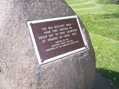
| | The Old Military Road From Fort Howard on Green Bay to Fort Crawford at Prairie du Chien, 1835. — — Map (db m36005) HM |
| On County Highway Y at Canyon Park Road, on the right when traveling west on County Highway Y. |
| | You are traveling the route of the Old Military Road, built in 1835-36, to connect Fort Crawford at Prairie du Chien and Fort Howard at Green Bay, via Fort Winnebago at "The Portage" between the Fox-Wisconsin rivers. The section from Prairie du . . . — — Map (db m36908) HM |
| On Dunroven Road at County Road DM, on the right when traveling south on Dunroven Road. |
| | In July, 1833, Lt. Alexander Center blazed a nearby oak, marking the 100-mile point of a military road he and James Doty were surveying. The Old Military Road, built from 1835 to 1837, connected Ft. Crawford at Prairie du Chien, Ft. Winnebago at . . . — — Map (db m36907) HM |
| On South Military Road at West 9th Street on South Military Road. |
| | Fort Howard, Green Bay
to Fort Crawford, Prairie du Chien
— — Map (db m36004) HM |
| On South Military Road at West 2nd Street, on the right when traveling north on South Military Road. |
| | The Military Road, built in 1835, became the first highway to cross the state. Congress appropriated $5,000 to connect the St. Lawrence and Mississippi River basins.
The troops at Fort Crawford constructed the road from Prairie du Chien to . . . — — Map (db m46182) HM |
Jun. 15, 2024