3 entries match your criteria.
Related Historical Markers
see relationship with other markers
By Brian Scott, August 9, 2009
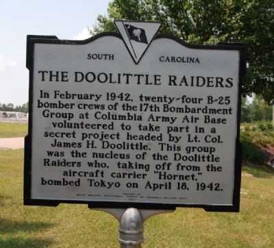
The Doolittle Raiders Marker
SHOWN IN SOURCE-SPECIFIED ORDER
| | Columbia Army Air Base
Built during 1941 as the Lexington County Airport, this airfield became the Columbia Army Air Base shortly after the U.S. entered World War II in December, 1941. The base was used to train crews for
medium bombardment . . . — — Map (db m10680) HM |
| | (Left Column)
Walterboro Army Airfield In the late 1920's and 1930's, a rough landing strip was made on the farm of C.C. Anderson just outside Walterboro. Starting in 1941, as part of the World War II effort,The U.S. Government . . . — — Map (db m22479) HM |
| |
[Front]:
Lake Murray islands, most notably Lunch Island (since 1945 also called Bomb Island or Doolittle Island), Shull Island, and Dreher Island, were used as bombing ranges during World War II. B-25 crews from the Columbia Army Air . . . — — Map (db m21535) HM |
May. 23, 2024