Near Ashford Road at Route B2163, on the right when traveling east.
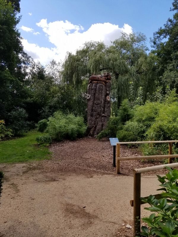
Aragon the Dragon
This Cedar Tree was planted over 200 years ago and once stood 23 metres tall. Examinations of the tree revealed it was suffering from severe decay and with its decline accelerating, it caused a risk to public safety. The decision . . . — — Map (db m128466) HM
Near Ashford Road at Route B2163, on the right when traveling east.
Leeds Castle
Leeds Castle gets its name from the ancient Saxon manor of Esledes recorded on this site in the Domesday Book of 1086. Following the Norman Conquest of 1066, many manors in Kent were fortified to remind the local people and any . . . — — Map (db m128467) HM
Near Ashford Road at Route B2163, on the right when traveling east.
The castle was built on two islands in the middle of a man-made moat, which was created by Edward I in the 13th century by diverting the river Len.
The surrounding estates were farmed to supply food for the castle's tenants and the needs of . . . — — Map (db m128470) HM
Near Ashford Road at Route B2163, on the right when traveling east.
New Castle
Built in 1822 by the Wykeham Martin family on the site of an earlier building.
Bridge Corridors
Replaced in the form you see today in the 19th century.
Clock Tower
15th century
Keep or ‘Gloriette’
13th century with . . . — — Map (db m128471) HM
Near Ashford Road at England Route B2163, on the right when traveling east.
Main Castle Island
The central tower of the Gatehouse built in 1278 and through which you have just passed served as a look-out point for the garrison soldiers responsible for defending the castle.
The management of the castle was left in . . . — — Map (db m128469) HM