2 entries match your criteria.
Related Historical Markers
By Cosmos Mariner, March 25, 2014
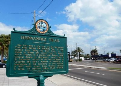
Hernandez Trail Marker (wide view)
SHOWN IN SOURCE-SPECIFIED ORDER
| On West King Street (State Road 520) west of South Cocoa Boulevard (U.S. 1), on the right when traveling west. |
| |
One half mile to the west ran the Hernandez Trail used during the Seminole War. It connected forts along the East Coast to Ft. Dallas in Miami and across from Ft. Pierce and Ft. Capron to Ft. Brooke near Tampa. Brig. General Joseph M. Hernandez, . . . — — Map (db m72606) HM |
| On North Dixie Avenue at Airport Road, on the left when traveling north on North Dixie Avenue. |
| | Hernandez Trail
1837-1928 — — Map (db m102313) HM |
May. 8, 2024