2 entries match your criteria.
Related Historical Markers
By Cosmos Mariner, July 3, 2016
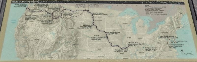
Marker detail: Lewis and Clark Expedition Map
SHOWN IN SOURCE-SPECIFIED ORDER
| On Devore Road north of 6th Street (U.S. 730), on the left when traveling north. |
| |
In 1804-06, Captains Meriwether Lewis and William Clark led about 40 soldiers and boatmen on an epic journey. President Thomas Jefferson commissioned this "Corps of Discovery" to find a route to the Pacific Ocean through the newly acquired . . . — — Map (db m114092) HM |
| On Devore Road north of 6th Street (U.S. 730), on the left when traveling north. |
| |
The Corps of Discovery descended the Columbia River in five dugout canoes made from pines felled at the mouth of the North Fork of the Clearwater River in Idaho.
Before McNary Dam harnessed this segment of the mighty Columbia, the river plunged . . . — — Map (db m114089) HM |
May. 19, 2024