5 entries match your criteria.
Related Historical Markers
Other Columbia Heights Heritage Trail markers entered in the Historical Marker database.
By Richard E. Miller, October 24, 2009
Main Street Marker (revese)
SHOWN IN SOURCE-SPECIFIED ORDER
| On Irving Street Northwest at 14th Street Northwest, on the right when traveling east on Irving Street Northwest. |
| |
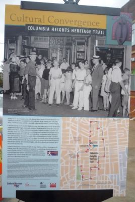
Fourteenth Street has always been the business backbone of Columbia Heights. Beginning in the 1890s, electric streetcars dropped passengers at nearly every corner, attracting commerce. By 1925 storefronts occupied the blocks between Euclid . . . — — Map (db m130750) HM |
| On Euclid Street Northwest at 13th Street Northwest, on the left when traveling east on Euclid Street Northwest. |
| |
These elegant 13th Street houses were constructed when racial separation was legal and widely accepted. In 1910 the deeds for many houses across 13th Street had covenants banning “any negro or colored persons.” Those on this side generally . . . — — Map (db m130748) HM |
| On Clifton Street Northwest east of 13th Street Northwest. |
| |
In the days of legally segregated public education (1862-1954), this school building was Central High, the gem of the School Board’s white division. But by 1949, it had few students, as the post-World War II suburban housing boom had drawn . . . — — Map (db m130752) HM |
| On 15th Street Northwest at Chapin Street Northwest, on the right when traveling north on 15th Street Northwest. |
| |
Wayland Seminary opened in Foggy Bottom just after the Civil War to train formerly enslaved people and others as “preachers and teachers for the South” and as missionaries to evangelize Africa. In 1875 it moved here, later merging . . . — — Map (db m130745) HM |
| On 16th Street Northwest south of Harvard Street Northwest. |
| |
Straight ahead is All Souls Church, Unitarian, long known for its social activism, starting with abolitionism in the 1820s and ranging through nuclear disarmament and interracial cooperation. During the segregation era, All Souls was one of . . . — — Map (db m130753) HM |
May. 5, 2024