3 entries match your criteria.
Related Historical Markers
These markers are in the "Walls within Walls" exhibit in Castle Clinton National Monument.
By Bill Coughlin, June 24, 2009
A prior iteration of the History of the Battery Marker
SHOWN IN SOURCE-SPECIFIED ORDER
| |
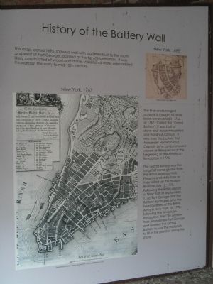
This map, dated 1695, shows a wall with batteries built to the south and west of Fort George, located at the tip of Manhattan. It was likely constructed of wood and stone. Additional works were added throughout the early to mid-18th century. The . . . — — Map (db m29319) HM |
| |
In spring 2006, during the South Ferry excavation in the Battery, four sections of a colonial era wall were identified by archaeologists. Although each of the four sections exhibited unique features, they are all likely part of the same wall, . . . — — Map (db m20306) HM |
| |
In 1790 the Common Council of the City of New York authorized the removal of stone and soil from Fort George and the Grand Battery to fill in the pier line along the Battery. Beginning in 1808, the defenses of the city were extended out into the . . . — — Map (db m148098) HM |
Apr. 29, 2024