2 entries match your criteria.
Related Historical Markers
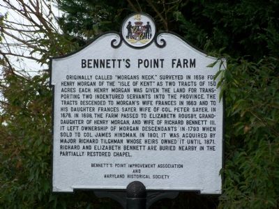
By Beverly Pfingsten, October 19, 2007
Bennett's Point Farm Marker
SHOWN IN SOURCE-SPECIFIED ORDER
| 1 ► Maryland, Queen Anne's County, Queenstown — Bennett’s Point Farm — |
| On Bennett’s Point Road, 0.2 miles south of Wye Ferry Road, on the right when traveling south. | |||
| 2 ► Maryland, Queen Anne's County, Queenstown — “Morgan’s Neck” / Richard Bennett III and Elizabeth Rousby — |
| On Ice House Point Road, 0.2 miles east of Bennett’s Point Road, on the right when traveling east. | |||