2 entries match your criteria.
Related Historical Markers
By Bill Kirchner, May 24, 2013
Captain Cook Monument
SHOWN IN SOURCE-SPECIFIED ORDER
| On Hawaii Route 50 at Panako Road, on the right when traveling west on State Route 50. |
| | In January, 1778, two ships under the command of British navigator Captain James Cook sighted the northwest coast of O'ahu. The next day they cruised from Maha'ulepu to Waimea Bay on Kaua'i where they set anchor. Acquainted with the Tahitian . . . — — Map (db m65777) HM |
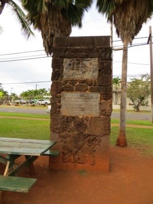
| | Marker panel on obelisk (1874): In Memory of the great circumnavigator
Captain James Cook, R.N. who discovered these islands on the 18th of January, 1770 and fell near this spot on the 14th of February, 1779. . . . — — Map (db m72497) HM |
May. 5, 2024