3 entries match your criteria.
Related Historical Markers
To better understand the relationship, study each marker in the order shown.
By Richard E. Miller, August 7, 2010
Forks of the Road Historical Site Marker, Panel 2
SHOWN IN SOURCE-SPECIFIED ORDER
| On Liberty Road south of St. Catherine St. (U.S. 61), on the right when traveling north. |
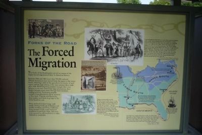
| | [Panel 1:]
Natchez in the Center of Slavery
Slavery is central to American history. The labor of enslaved African Americans built much of the nation’s wealth and enabled it to gain its economic independence. The enslavement of people . . . — — Map (db m41533) HM |
| On Liberty Road at St Catherine Street and Devereaux Drive (Business U.S. 61), on the left when traveling north on Liberty Road. |
| | Site of the South's second largest slave market in the 19th century. Enslaved people were also once sold on city streets and at the landing at Natchez Under the Hill. Natchez slaves were freed in July, 1863, when Union troops occupied the city. The . . . — — Map (db m37433) HM |
| On West Street at Duke Street (Virginia Route 236) on West Street. |
| | Text, upper half of marker panel:
This house, built by Emmanuel Jones by 1888, stands at the corner of a block that witnessed the extremes of 19th century African American experience. From a slave trading company to significant . . . — — Map (db m46124) HM |
Apr. 26, 2024