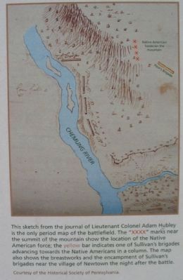
To protect the village of Newtown, about 600 Native American warriors, 200 loyalists, and a handful of British soldiers erected and camouflaged a half-mile-long breastwork of logs in the village overlooking a creek, hoping to surprise Sullivan's . . . — — Map (db m33550) HM
On U.S. 20 at Gravel Road (County Route 101), on the left when traveling north on U.S. 20.
Routes of the armies of
General John Sullivan
and
General James Clinton
1779
An expedition against the hostile Indian nations which checked the aggression of the English and Indians on the frontiers of New York and Pennsylvania, . . . — — Map (db m8069) HM
On Little Britain Road (New York State Route 207) at Beattie Rd, on the right when traveling west on Little Britain Road.
Built by General James Clinton Commander of NY troops during the Revolutionary War, presided at surrender at Yorktown 1781. Town Clerk & Supervisor of New Windsor, died here Dec. 22, 1812 — — Map (db m44245) HM
On Main Street near Fair Street, on the right when traveling east.
Indian Agent - Land Speculator
Lived in Pioneer Log House
Located Here 1769-1770.
General James Clinton's
Headquarters Here 1779.
— — Map (db m43351) HM
On Route 20 (U.S. 20) at Continental Road, on the right when traveling east on Route 20.
This monument is
erected to the
memory of
Gen'l James Clinton
Born 1736 died 1812
& marks a point on
the line of march
of his troops from
Mohawk River to
Otsego Lake in
Jvne 1779
General James Clinton
Chapter DAR . . . — — Map (db m42494) HM
On New York State Route 14 at Kashong Point Road, on the right when traveling north on State Route 14.
An expedition against the hostile Indian nations which checked the aggressions of the English and Indians on the frontiers of New York and Pennsylvania, extending westward the dominion of the United States. — — Map (db m68624) HM WM
On Lakeshore Drive at City Pier, on the right when traveling south on Lakeshore Drive.
An expedition against the hostile Indian nations which checked the aggressions of the English and Indians on the frontiers of New York and Pennsylvania, extending westward the dominion of the United States — — Map (db m61893) HM