4 entries match your criteria.
Related Historical Markers
Other buried ships along the old San Francisco waterfront.
By Barry Swackhamer, April 8, 2014
Business on the Wharf Marker
SHOWN IN SOURCE-SPECIFIED ORDER
| On The Embarcadero near Broadway, on the right when traveling north. Reported permanently removed. |
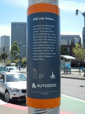
| | This marker is one of a series intended to commemorate the 150 years of the Port of San Francisco. It is composed of a captioned photograph and text entitled Did you know... mounted on a cylindrical metal pylon.
Derby-hatted Tom . . . — — Map (db m201264) HM |
| Near Clay Street at Battery Street, on the left when traveling east. |
| | The remains of the gold rush supply ship, the General Harrison, lie beneath this building. The sidewalk treatment reminds us that Clay Street was once a wharf at the edge of San Francisco Bay with tidal mud flats to the north, and in 1850 ships . . . — — Map (db m70839) HM |
| On Clay Street near Sansome Street, on the left when traveling east. |
| |
The emigrant ship Niantic stood on this spot in the early days "when the water came up to Montgomery Street." Converted to other uses, it was covered with a shingle roof with offices and stores on the deck, at the level which was . . . — — Map (db m41125) HM |
| On Pacific Avenue at Battery Street on Pacific Avenue. |
| | After a 178 day voyage from New York via Cape Horn in 1849 the sailing ship "Arkansas" arrived in San Francisco Bay. Among her 112 passengers were 76 Methodists, all bound for the gold fields or church propagation. The ship was nearly lost while . . . — — Map (db m33272) HM |
May. 26, 2024