Fort Mitchell in Russell County, Alabama — The American South (East South Central)
The Creeks Today
— Creek Heritage Trail —
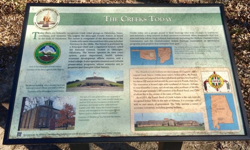
Creeks today are a people proud of their heritage who hold strongly to traditions and maintain a deep interest in their ancestral homeland. Many frequently visit this area and help advise local cultural institutions, including the Historic Chattahoochee Commission and the Chattahoochee Indian Heritage Association, in developing programs and projects that interpret their past.
[Photo Captions]
{Top left}
Seal of the Muscogee Creek Nation
Courtesy of the Muscogee (Creek) Nation
{Middle left}
The Mound Building, which houses the Creek National Council Offices and Judicial Offices
Courtesy of the Muscogee (Creek) Nation
{Bottom left}
The seat of Creek government was originally a two-story log cabin. The Creek Council House was built in 1878 on the foundation of that earlier structure, and served as the Creek National Capitol in 1906. Today the Council House is owned and managed by the Muscogee (Creek) Nation and is a National Historic Landmark.
Courtesy of Oklahoma Tourism and Recreation Department
{Right side Map}
The majority of the enrollment of approximately 75,000 people in the Creek Nation lives in nine counties in east-central Oklahoma. An additional 10,000 members of the tribe live outside of this area.
Map showing boundaries of the Muscogee (Creek) Nation
{Bottom right insert & photos}
The Poarch Creek Indians are descendants of a segment of the original Creek Nation. Unlike many eastern Indian tribes, the Poarch Creeks were not removed from their tribal lands and have lived together for almost 200 years in and around the reservation in Poarch, Alabama. The reservation is located eight miles northwest of Atmore, Alabama in rural Escambia County, and about sixty miles northeast of Mobile. There are approximately 2,500 members of the Poarch Band, over 1,000 of whom live in the vicinity of the town of Poarch.
As of 2013, the Poarch Band of Creek Indians is the only federally
recognized Indian Tribe in the state of Alabama. It is sovereign nation with its own system of government. The Tribe operates a variety of economic enterprises, including gaming facilities.
Erected 2014 by the Historic Chattahoochee Commission and the Russell County Convention and Visitor’s Bureau.
Topics. This historical marker is listed in this topic list: Native Americans. A significant historical year for this entry is 1878.
Location. 32° 20.69′ N, 85° 1.297′ W. Marker is in Fort Mitchell, Alabama, in Russell County. Marker can be reached from County Route 165, 2.3 miles south of Nuckols Road (Road 39). Marker is located to the back side of the Chattahoochee Indian Heritage Center Monument adjacent to Fort Mitchell National Historic Landmark Site. Touch for map. Marker is at or near this postal address: 561 Highway 165, Fort Mitchell AL 36856, United States of America. Touch for directions.
Other nearby markers. At least 8 other markers are within walking distance of this marker. The Creek Trail of Tears (here, next to this marker); Removal of the Creeks (a few steps from this marker); Creek Towns (within shouting distance of this marker); Cultural Exchange and Cooperation (within shouting distance of this marker); The Creek Nation / The Chattahoochee Indian Heritage Center (within shouting distance of this marker); The Census of 1832
(within shouting distance of this marker); Fort Mitchell and Creek Removal (about 300 feet away, measured in a direct line); Indian Ball Ground (about 300 feet away). Touch for a list and map of all markers in Fort Mitchell.
Also see . . . Wikipedia article on the Poarch Band of Creek Indians in Alabama. (Submitted on March 7, 2017, by Mark Hilton of Montgomery, Alabama.)
Credits. This page was last revised on July 10, 2018. It was originally submitted on March 7, 2017, by Mark Hilton of Montgomery, Alabama. This page has been viewed 422 times since then and 40 times this year. Photos: 1, 2, 3. submitted on March 7, 2017, by Mark Hilton of Montgomery, Alabama.


