Straban Township near Gettysburg in Adams County, Pennsylvania — The American Northeast (Mid-Atlantic)
Benner's Hill
Colonel Charles S. Wainwright
1st Corps Artillery Brigade, USA
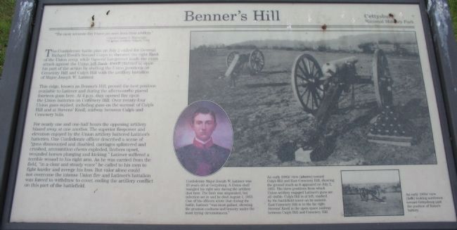
The Confederate battle plan on July 2 called for General Richard Ewell's Second Corps to threaten the right flank of the Union army, while General Longstreet made the main attack against the Union left flank. Ewell planned to open his part of the action by shelling the Union positions on Cemetery Hill and Culp's Hill with the artillery battalion of Major Joseph W. Latimer.
This ridge, known as Benner's Hill, proved the best location available to Latimer and during the afternoon he placed fourteen guns here. At 4 p.m. they opened fire upon the Union batteries on Cemetery Hill. Over twenty-four Union guns replied, including guns on the summit of Culp's Hill and at Stevens' Knoll, midway between Culp's and Cemetery Hills.
For nearly one and one-half hours the opposing artillery blazed away at one another. The superior firepower and elevation enjoyed by the Union artillery battered Latimer's batteries. One Confederate officer described a scene of "guns dismounted and disabled, carriages splintered and crushed, ammunition chests exploded, limbers upset, wounded horses plunging and kicking." Latimer suffered a terrible wound to his right arm. As he was carried from the field "in a clear and steady voice" he called to his men to fight harder and avenge his loss. But valor alone could not overcome the intense Union fire and Latimer's battalion was forced to withdraw to cover, ending the artillery conflict on this part of the battlefield.
Erected by Gettysburg National Military Park.
Topics. This historical marker is listed in this topic list: War, US Civil. A significant historical month for this entry is July 1864.
Location. This marker has been replaced by another marker nearby. It was located near 39° 49.658′ N, 77° 12.821′ W. Marker was near Gettysburg, Pennsylvania, in Adams County. It was in Straban Township. Marker was on Benner's Hill Loop, 0.1 miles south of Hanover Road (Pennsylvania Highway 116), on the right when traveling south. Located in the Benner's Hill section of Gettysburg National Military Park. Touch for map. Marker was in this post office area: Gettysburg PA 17325, United States of America. Touch for directions.
Other nearby markers. At least 8 other markers are within walking distance of this location. An Unequal Contest (here, next to this marker); Carpenter's Battery - Latimer's Battalion (a few steps from this marker); Latimer's Battalion (within shouting distance of this marker); Dement's Battery - Latimer's Battalion (about 300 feet away, measured in a direct line); Brown's Battery - Latimer's Battalion (about 300 feet away); Raine's Battery - Latimer's Battalion (about 500 feet away); Graham's Battery - Dance's Battalion (about 500 feet away); Milledge's Battery - Nelson's Battalion (about 800 feet away). Touch for a list and map of all markers in Gettysburg.
More about this marker. A portrait of Latimer carries the caption, Confederate Major Joseph W. Latimer was 19 years old at Gettysburg. A Union shell mangled his right arm during the artillery duel here. The limb was amputated but infection set in and he died August 1, 1863. One of his officers wrote that during the battle, Latimer, "was most gallant, showing the greatest coolness and bravery under the most trying circumstances."
The main photo on the right show An early 1900's view toward Culp's Hill and East Cemetery Hill, showing the ground much as it appeared on July 2, 1863. The three positions from which Union artillery engaged Latimer's guns are all visible. Culp's Hill is at the left, marked by the battlefield tower on its summit. East Cemetery Hill is to the far right. Stevens' Knoll is the open space midway between Culp's Hill and Cemetery Hill.
A smaller photo to the

Photographed By Craig Swain
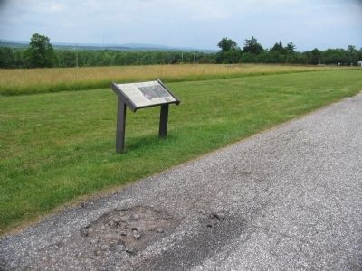
3. View from Brenner's Hill Today
The view is much less open today than it was in the early 1900's. Note the location of the water tower in relation to Cemetery Hill. The water tower stands just northeast of Cemetery Hill between Baltimore Street and East Confederate Avenue.
Related markers. Click here for a list of markers that are related to this marker. Benner's Hill Virtual Tour by Markers
Credits. This page was last revised on February 7, 2023. It was originally submitted on August 31, 2008, by Craig Swain of Leesburg, Virginia. This page has been viewed 2,294 times since then and 27 times this year. Photos: 1, 2, 3. submitted on August 31, 2008, by Craig Swain of Leesburg, Virginia.

