Cumberland Township near Gettysburg in Adams County, Pennsylvania — The American Northeast (Mid-Atlantic)
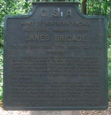
Lane's Brigade
Pender's Division - Hill's Corps
— Army of Northern Virginia —
Army of Northern Virginia
Hill's Corps Pender's Division
Lane's Brigade
7th. 18th. 28th. 33rd. 37th. North Carolina
Infantry
July 1 Crossed Willoughby Run about 3.30 and advanced on the right of the Division in the final and successful movement against the Union forces on Seminary Ridge held back Union cavalry which threatened the flank and had a sharp conflict at the stone wall on Seminary Ridge just south of Fairfield Road.
July 3 Lay with its right in McMillan's Woods with skirmish line advanced.
July 3 In Longstreet's assault the Brigade supported the centre of Pettigrew's Division advancing in good order under the storm of shot and shell and when near the Union works north of the Angle pushed forward to aid the fragments of the front line in the final struggle and was among the last to retire.
July 4 After night withdrew and began the march to Hagerstown.
Present 1355. Killed 41, wounded 348, missing 271. Total 660.
Erected 1910 by Gettysburg National Military Park Commission.
Topics. This historical marker is listed in this topic list: War, US Civil. A significant historical year for this entry is 1355.
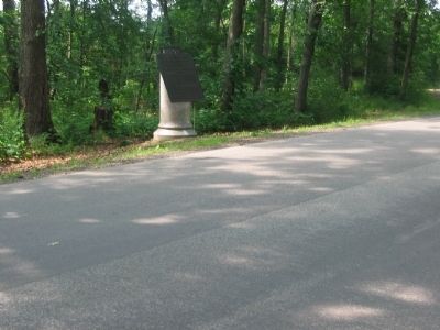
Location. 39° 49.253′ N, 77° 14.776′ W. Marker is near Gettysburg, Pennsylvania, in Adams County. It is in Cumberland Township. Marker is on West Confederate Avenue, on the left when traveling south. Located on the McMillan Woods section of Confederate Avenue, just south of the McMillan Woods Youth Campground, in Gettysburg National Military Park. Touch for map. Marker is in this post office area: Gettysburg PA 17325, United States of America. Touch for directions.
Other nearby markers. At least 8 other markers are within walking distance of this marker. Zimmerman's Battery - Pegram's Battalion (within shouting distance of this marker); Thomas's Brigade (within shouting distance of this marker); McGraw's Battery - Pegram's Battalion (within shouting distance of this marker); Pegram's Battalion (within shouting distance of this marker); Crenshaw's Battery - Pegram's Battalion (about 300 feet away, measured in a direct line); Brander's Battery - Pegram's Battalion (about 300 feet away); Pender's Division (about 300 feet away); Scales's Brigade (about 400 feet away). Touch for a list and map of all markers in Gettysburg.
Also see . . . Report of Brig. Gen. James H. Lane. Shotgun's American Civil War Home website entry:
General Lane's included a rather detailed after action report, including this account of the great charge on July 3:
As soon as Pettigrew's command gave back, Lowrance's brigade and my own, without ever having halted, took position on the left of the troops which were still contesting the ground with the enemy. My command never moved forward more handsomely. The men reserved their fire, in accordance with orders, until within good range of the enemy, and then opened with telling effect, repeatedly driving the cannoneers front their pieces, completely silencing the guns in our immediate front, and breaking the line of infantry which was formed on the crest of the hill. We advanced to within a few yards of the stone wall, exposed all the while to a heavy raking artillery fire from the right. My left was here very much exposed, and a column of the enemy's infantry was thrown forward in that direction, which enfiladed my whole line. This forced me to withdraw my brigade, the troops on my right having already done so. (Submitted on September 15, 2008, by Craig Swain of Leesburg, Virginia.)

Photographed By Craig Swain
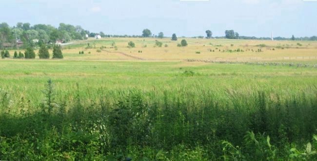
3. Lane's Brigade Advance on July 3
Looking east from Confederate Avenue toward Cemetery Ridge. Lane's Brigade was a part of the left side of what became known as Pickett's Charge, along with Brockenbrough's (then under Col. Robert Mayo) and Davis' Brigades from Heth's Division (then under Pettigrew). Those two brigades were flanked by fire from a lone Federal regiment, the 8th Ohio, and fell back, exposing Lane's men. Undaunted, the North Carolina regiments pressed forward and reached the stone wall just south of Ziegler's Grove at the Bryan House. There the Brigade was flanked by the 108th and 126th New York. In this view, the Brigade's line of march was across the open ground just left of center. A white house on the left is the Bryan House, roughly the left flank of Lane's line when reaching Cemetery Ridge.
Credits. This page was last revised on February 7, 2023. It was originally submitted on September 15, 2008, by Craig Swain of Leesburg, Virginia. This page has been viewed 1,139 times since then and 21 times this year. Photos: 1, 2, 3. submitted on September 15, 2008, by Craig Swain of Leesburg, Virginia.

