Cumberland Township near Round Top in Adams County, Pennsylvania — The American Northeast (Mid-Atlantic)
Battery D Fifth U.S. Artillery
Artillery Brigade - Fifth Corps
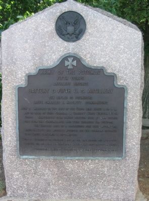
— Army of the Potomac —
Fifth Corps
Artillery Brigade
Battery D Fifth U.S. Artillery
Six Rifled 10 pounders
Lieut. Charles E. Hazlett commanding
July 2 Marched to the left of the Union Line about 4.30 p.m. and in rear of Brig. General J. Barnes's First Division Fight Corps. Immediately upon taking position here at 5.45 opened fire upon the Confederates who were engaging the Division.
The Battery kept up a continuous fire until after dark. Lieut. Hazlett was mortally wounded and the command devolved upon Lieut. Benjamin F. Rittenhouse.
July 3 Remained in position and in the afternoon did effective service on the lines of infantry engaged in Longstreet's assault.
Casualties killed 1 officer and 6 men. Wounded 6 men.
Erected 1907 by Gettysburg National Military Park Commission.
Topics. This historical marker is listed in this topic list: War, US Civil. A significant historical month for this entry is July 1790.
Location. 39° 47.519′ N, 77° 14.198′ W. Marker is near Round Top, Pennsylvania, in Adams County. It is in Cumberland Township. Marker can be reached from Sykes Avenue, on the left when traveling north. Located at stop 8, Little Round Top, on the driving tour of Gettysburg National Military Park. Touch for map . Marker is in this post office area: Gettysburg PA 17325, United States of America. Touch for directions.
Other nearby markers. At least 8 other markers are within walking distance of this marker. 91st Pennsylvania Volunteer Regiment (a few steps from this marker); The Deadly Sharpshooters (a few steps from this marker); 91st Pennsylvania Infantry (a few steps from this marker); The Valley of Death (a few steps from this marker); The Union Fishhook (within shouting distance of this marker); The Eye of General Warren (within shouting distance of this marker); Third Brigade (within shouting distance of this marker); Defense of Little Round Top (within shouting distance of this marker). Touch for a list and map of all markers in Round Top.

Photographed By Craig Swain, July 24, 2008
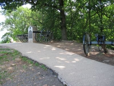
2. Battery D Fifth U.S. Artillery Position
Two 3-inch Parrott Rifles and two 2.9-inch Parrott Rifles represent the position held by Hazlett's Battery. The two calibers were generally called "10-pounder" based on the weight of their shot. In 1863, the Federal army decided to standardize the 3-inch caliber, and the new type replaced the 2.9-inch guns in time.

Photographed By Craig Swain, July 24, 2008
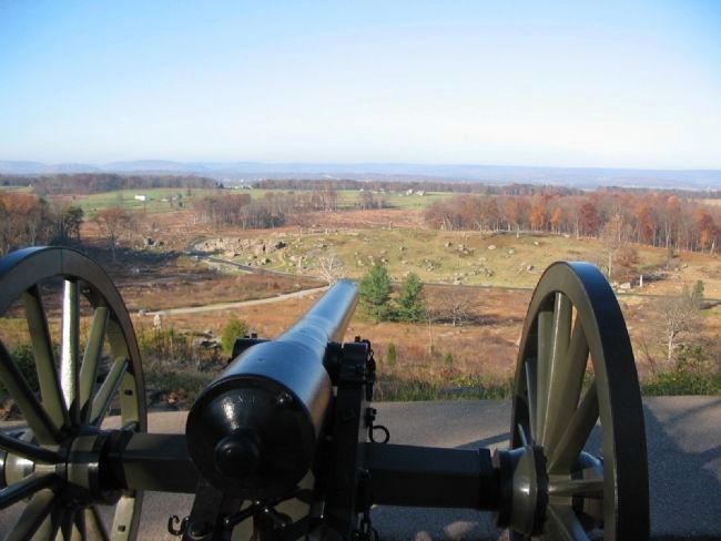
3. Gunner's View from the Parrotts
Looking down the barrel of a 3-inch Parrott on top of Little Round Top. Notice how rapidly the hill slopes off into the valley below. Civil War artillery had limitations on elevation which prevented extreme angles. The guns on Little Round Top could not depress to fire upon targets in the valley directly below the hill. But their fire was quite effective against targets at the Devil's Den and other points on Houck's Ridge extending to the north.

Photographed By Craig Swain, July 24, 2008
4. Devil's Den, Houck's Ridge, and the Valley of Death
Seen from just forward of the battery. The Devil's Den is to the far left. Houck's Ridge extends to the north (right). The valley between the ridge and Little Round Top became known as the Valley of Death.

Photographed By Craig Swain, November 11, 2008
5. Gunner's View of Devil's Den
Looking down the barrel of a 3-inch Parrott Model 1863 toward the Devil's Den. Almost dead center in the photograph is the 99th Pennsylvania Monument, on the the top of Houck's Ridge. The rocks of the Devil's Den are to the left of that point.
Credits. This page was last revised on February 7, 2023. It was originally submitted on September 24, 2008, by Craig Swain of Leesburg, Virginia. This page has been viewed 1,497 times since then and 11 times this year. Photos: 1, 2, 3, 4. submitted on September 24, 2008, by Craig Swain of Leesburg, Virginia. 5. submitted on January 1, 2009, by Craig Swain of Leesburg, Virginia.
