Cumberland Township near Gettysburg in Adams County, Pennsylvania — The American Northeast (Mid-Atlantic)
Kershaw's Brigade
McLaws's Division - Longstreet's Corps
— Army of Northern Virginia —
Army of Northern Virginia
Longstreet's Corps McLaws's Division
Kershaw's Brigade
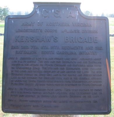
2nd. 3rd. 7th. 8th. 15th. Regiments and 3rd.
Battalion South Carolina Infantry
July 2 Arrived at 3.30 p.m. and formed line here. Advanced about 4.30 p.m. to battle. The 8th and 2nd Regiments and 3rd Battalion charged in the attack on Peach Orchard and Batteries near there on Wheatfield Road. The 7th and 3rd Regiments were engaged in the long and severe conflict at and around the Loop. The 15th regiment fought on Rose Hill and in the ravine and forest beyond. Late in the evening the Brigade took part in the general advance by which the Union forces were forced from Wheatfield and across Plum Run Valley. At dark under orders it retired to Peach Orchard.
July 3 At Peach Orchard until noon. Then sent further to front. At 1 p.m. under orders resumed position here extending line to right and keeping in touch with Hood's Division on the left.
July 4 About midnight began the march to Hagerstown Md.
Present about 1800. Losses 630.
Erected 1910 by Gettysburg National Military Park Commission.
Topics. This historical marker is listed in this topic list: War, US Civil. A significant historical month for this entry is July 1967.
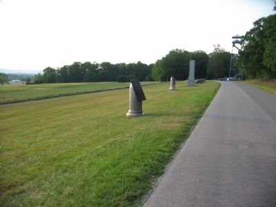
Location. 39° 47.911′ N, 77° 15.355′ W. Marker is near Gettysburg, Pennsylvania, in Adams County. It is in Cumberland Township. Marker is on West Confederate Avenue, on the right when traveling south. Located just south of the Longstreet Observation tower in Gettysburg National Military Park. Touch for map. Marker is in this post office area: Gettysburg PA 17325, United States of America. Touch for directions.
Other nearby markers. At least 8 other markers are within walking distance of this marker. Semmes's Brigade (a few steps from this marker); Manly's Battery - Cabell's Battalion (within shouting distance of this marker); Georgia (within shouting distance of this marker); Carlton's Battery - Cabell's Battalion (within shouting distance of this marker); South Carolina (within shouting distance of this marker); McLaws's Division (about 300 feet away, measured in a direct line); a different marker also named Carlton's Battery - Cabell's Battalion (about 400 feet away); The Ashland Virginia Artillery (about 500 feet away). Touch for a list and map of all markers in Gettysburg.
Related markers. Click here for a list of markers that are related to this marker. Kershaw's Brigade Advance as seen by markers.
Also see . . . Brig. Gen. J. B. Kershaw's Report. Kershaw provided a rather detailed report of the actions on July 2. (Submitted on October 10, 2008, by Craig Swain of Leesburg, Virginia.)

Photographed By Craig Swain
3. Kershaw's Brigade Line of Advance
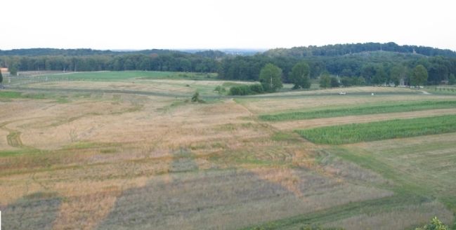
Looking from the Longstreet Observation Tower to the east. Emmitsburg Road runs from left to right, across the center of this photo. Monuments on the south edge of the Peach Orchard are on the left. Little Round Top is on the far right distance. Just right of center are the "Rose Woods" concealing the ravine mentioned in the tablet text. The Rose Farm is at the end of a farm lane seen extending off the Emmitsburg Road on the right. In the afternoon of July 2, Kershaw's Brigade advanced on line across the open fields in the foreground toward the east, with the regiments spread almost the full frame of the photo.
Credits. This page was last revised on February 7, 2023. It was originally submitted on October 10, 2008, by Craig Swain of Leesburg, Virginia. This page has been viewed 958 times since then and 19 times this year. Photos: 1, 2, 3. submitted on October 10, 2008, by Craig Swain of Leesburg, Virginia.

