Near Petersburg in Dinwiddie County, Virginia — The American South (Mid-Atlantic)
The Breakthrough at Hart Farm
The Breakthrough Trail
— Pamplin Historical Park —
- Sergeant Albert C. Harrison, Company G, 14th New Jersey Infantry Regiment
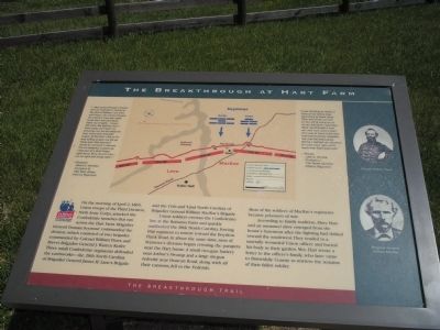
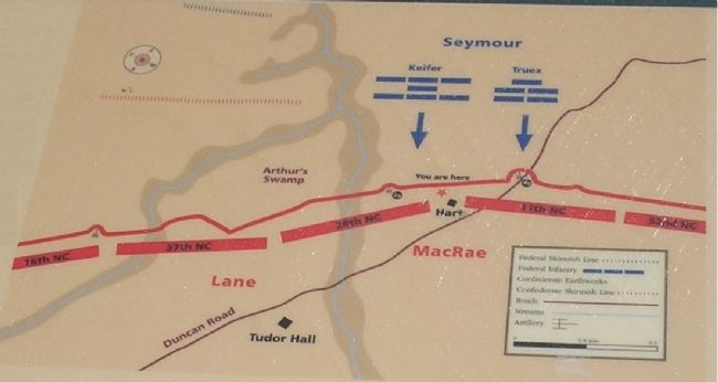
On the morning of April 2, 1865, Union troops of the Third Division, Sixth Army Corps, attacked the Confederate trenches that ran across the Hart Farm. Brigadier General Truman Seymour commanded the division, which consisted of two brigades commanded by Colonel William Truex and Brevet Brigadier General J. Warren Keifer. Three small Confederate regiments defended the earthworks – the 28th North Carolina of Brigadier General James H. Lane’s Brigade and the 11th and 52nd North Carolina of Brigadier General William MacRae’s Brigade.
Union soldiers overran the Confederate line at the Boisseau Farm and quickly outflanked the 28th North Carolina, forcing that regiment to retreat toward the Boydton Plank Road. At about the same time, men of Seymour’s division began crossing the parapets near the Hart house. A small two-gun battery near Arthur’s Swamp and a large six-gun redoubt near Duncan Road, along with all their cannons, fell to the Federals. Most of the soldiers of MacRae’s regiments became prisoners of war.
According to family tradition, Mary Hart and an unnamed slave emerged from the house’s basement after the fighting had shifted toward the southwest. They tended to a mortally wounded Union officer and buried his body in their garden. Mrs. Hart wrote a letter to the officer’s family, who later came to Dinwiddie County to retrieve the remains of their fallen soldier.
“I was shooting at Yanks in front of me where they were thick as black birds. They had broke our line on our left & come on us on our left flank. I had seen them, but thought it was our own men until a Cap’t who was in front of his men with sword drawn whacked me over the head twice. Before I realized my situation his men were right at his heels with fixed bayonets.”
- Private John C. Warlick, Company I, 11th North Carolina Infantry Regiment
Erected by Pamplin Historical Park.
Topics. This historical marker is listed in this topic list: War, US Civil. A significant historical date for this entry is April 2, 1920.
Location. 37° 10.611′ N, 77° 28.603′ W. Marker is near Petersburg, Virginia, in Dinwiddie County. Marker can be reached from Duncan Road (Virginia Route 670), on the left when traveling south. Marker is in Pamplin Historical Park, on the Hart House spur of the Breakthrough Trail. Touch for map. Marker is in this post office area: Petersburg VA 23803, United States of America. Touch for directions.
Other nearby markers. At least 8 other markers are within walking distance of this marker. The Hart House (within shouting distance of this marker); The Battle of Harmon Road (within shouting distance of this marker); “The Cannons’ Flashes Lit Up the Terrible Scene” (about 400 feet away, measured in a direct line); Sixth Maryland Infantry Monument (about 800 feet away); “The Strongest Line of Works Ever Constructed” (approx. ¼ mile away); The Hart Farm (approx. ¼ mile away); McGowan’s South Carolina Brigade (approx. ¼ mile away); Petersburg Breakthrough Battlefield (approx. ¼ mile away). Touch for a list and map of all markers in Petersburg.
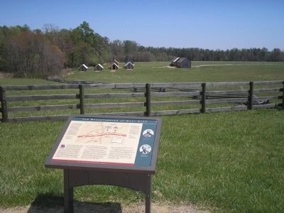
More about this marker. The top of the marker contains a battle map of the Breakthrough attack, indicating Confederate fortifications, Union troop movements and the location of the marker. The right side of the marker features photographs of Colonel William Truex and Brigadier General William MacRae.
Also see . . . Breakthrough at Petersburg. The American Civil
War website. (Submitted on January 17, 2009, by Bill Coughlin of Woodland Park, New Jersey.)
Credits. This page was last revised on February 2, 2023. It was originally submitted on January 17, 2009, by Bill Coughlin of Woodland Park, New Jersey. This page has been viewed 1,233 times since then and 23 times this year. Last updated on November 13, 2021, by Bradley Owen of Morgantown, West Virginia. Photos: 1, 2, 3. submitted on January 17, 2009, by Bill Coughlin of Woodland Park, New Jersey. 4. submitted on November 13, 2021, by Bradley Owen of Morgantown, West Virginia. 5. submitted on January 17, 2009, by Bill Coughlin of Woodland Park, New Jersey. • J. Makali Bruton was the editor who published this page.
