Shenandoah in Page County, Virginia — The American South (Mid-Atlantic)
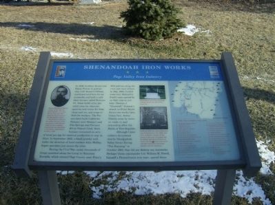
Shenandoah Iron Works
Page Valley Iron Industry
During the Civil War, many thousands of troops marched along the Luray to Staunton Turnpike which entered Page County near price’s Mill and ran along the river just west of here. In May 1862, Confederate Gen. Richard S. Ewell’s men passed by on their way to join Gen. Thomas J. “Stonewall” Jackson’s attack on Front Royal. About two weeks later, Union Gen. James Shields came by twice, en route to and retreating after the Battle of Port Republic.
Although Union soldiers devastated nearby Shenandoah Valley farms during “The Burning” in October 1864, they did not destroy any ironworks. Perhaps Union commander Col. William H. Powell, himself a Pennsylvania iron man, spared them.
Erected 2006 by Summers-Koontz #490, in partnership with the Shenandoah Valley Battlefields Foundation, Virginia Civil War Trails, and the Town of Shenandoah.
Topics and series. This historical marker is listed in these topic lists: Industry & Commerce • War, US Civil. In addition, it is included in the Virginia Civil War Trails series list. A significant historical month for this entry is May 1862.
Location. 38° 29.068′ N, 78° 37.347′ W. Marker is in Shenandoah, Virginia, in Page County. Marker is on Maryland Avenue (County Route 602), on the right when traveling south. Touch for map. Marker is in this post office area: Shenandoah VA 22849, United States of America. Touch for directions.
Other nearby markers. At least 8 other markers are within 2 miles of this marker, measured as the crow flies. The Stevens Cottage 1890 (about 500 feet away, measured in a direct line); WWI Cannon 1906 Model (about 500 feet away); Shenandoah Historic District (approx. 0.2 miles away); Veterans Memorial (approx. ¼ mile away); Shenandoah World War I & II Memorial (approx. 0.8 miles away); Veterans Memorial Fields (approx. 0.8 miles away); Shenandoah Iron Works District War Memorial (approx. 0.8 miles away); History of Verbena (approx. 1.3 miles away). Touch for a list and map of all markers in Shenandoah.
More about this marker. In the upper left is a portrait of Simeon Beauford Gibbons, colonel of the 10th Virginia Infantry,
was born not far from this site, along the South Fork of the Shenandoah River. A VMI graduate and present before the war at the execution of John Brown, Gibbons was a popular commander but was killed at the Battle of McDowell on May 8, 1862.
In the upper center is a photo of The original anvil from the forge of Shenandoah Iron Works Furnace No. 1.
Below it is a photo of the Forrer Mansion. Built ca. 1855, the Forrer mansion was dismantled in the 1960s, and little evidence remains of the house or the iron ore legacy left by Daniel and Henry Forrer. At war’s end, the Forrers were land rich but cash poor and subsequently sold the business.
On the right is a map showing Civil War sites of Page County.
Also see . . . Avenue of Armies: Civil War Sites and Stories of Luray and Page County, Virginia. (Submitted on March 20, 2009, by Robert H. Moore, II of Winchester, Virginia.)
Credits. This page was last revised on February 3, 2020. It was originally submitted on March 4, 2009, by Robert H. Moore, II of Winchester, Virginia. This page has been viewed 4,599 times since then and 119 times this year. Photos: 1, 2. submitted on March 4, 2009, by Robert H. Moore, II of Winchester, Virginia. • Craig Swain was the editor who published this page.

