Fremont in Sandusky County, Ohio — The American Midwest (Great Lakes)
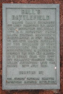
Ballís Battlefield
Erected by Col. George Croghan Chapter Daughters of the American Revolution (DAR).
Topics and series. This historical marker is listed in this topic list: War of 1812. In addition, it is included in the Daughters of the American Revolution, and the Former U.S. Presidents: #09 William Henry Harrison series lists. A significant historical date for this entry is July 30, 1813.
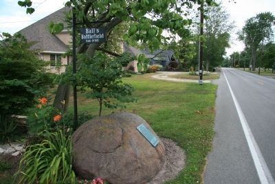
Location. 41° 19.777′ N, 83° 8.852′ W. Marker is in Fremont, Ohio, in Sandusky County. Marker is at the intersection of Buckland Avenue and Tucker Road, on the right when traveling north on Buckland Avenue. Touch for map. Marker is at or near this postal address: 2401 Buckland Ave, Fremont OH 43420, United States of America. Touch for directions.
Other nearby markers. At least 8 other markers are within walking distance of this marker. Portage Trail (approx. 0.7 miles away); Sandusky-Scioto Trail (approx. 0.9 miles away); Emery Deitemyer (approx. one mile away); Henry H. Clayton (approx. one mile away); Carl H. Drenning (approx. one mile away); Charles Englehart (approx. one mile away); Isaac N. Courtney (approx. one mile away); Sgt. James J. Feeney (approx. one mile away). Touch for a list and map of all markers in Fremont.
More about this marker. This historic marker, and the historic event itself, is located along what was once the major travel route through Ohio for Native Americans and early frontiersmen traveling between Fort Duquesne and Detroit, called the Sandusky-Scioto Trail. Later, during the War of 1812, this portion of the trail would become known as the Harrison Trail.
Regarding Ballís Battlefield. This historic marker recognizes an event that was part of General William Henry Harrisonís Northwestern Theater of operations. General Harrisonís goal was to retake Detroit and launch a successful invasion of Canada. In preparation of this planned invasion General Harrison had built a string of forts northward along the Sandusky River Valley in order to protect his lines of supply and communication.
In the summer of 1813, after their unsuccessful siege of Fort
Meigs, along the banks of the Maumee River, the British and their Native American allies decided to disrupt General Harrisonís operations in the Sandusky River Valley by seeking to attack and capture the northern most of Harrisonís chain of forts, Fort Stephenson.
Upon discovering the British intentions, General Harrison acted quickly to avert what he believed would be a military disaster, and ordered the immediate withdrawal of the American forces from Fort Stephenson, prior to the arrival of the vastly numerically superior British and Native American forces. However, the messenger got lost on route to the fort and by the time that the fortís commander, Major Croghan, received his orders, the British had already arrived. In Major Croghanís view it was now too late to withdraw from the fort without exposing his men to an attack, out in the open, from a foe with far superior numbers to his. So he decided to ignore his orders and take his chances within the defenses of Fort Stephenson.
It was when General Harrison realized that his orders to withdraw from the fort had not been obeyed, but not fully knowing why, that he ordered Col. Wells to immediately proceed to Fort Stephenson under the protect of Major Ball and his Light Dragoons and to relieve Major Croghan of his command. And it was while Col. Wells and his escort were nearing Fort Stephenson that the ambush
and battle took place.
Related markers. Click here for a list of markers that are related to this marker. To better understand the relationship, study each marker in the order shown.
Credits. This page was last revised on February 22, 2024. It was originally submitted on April 15, 2009, by Dale K. Benington of Toledo, Ohio. This page has been viewed 2,163 times since then and 68 times this year. Last updated on February 13, 2024, by Carolyn Sanders of Plano, Texas. Photos: 1, 2, 3. submitted on April 15, 2009, by Dale K. Benington of Toledo, Ohio. • Devry Becker Jones was the editor who published this page.


