Kirkwood in Alpine County, California — The American West (Pacific Coastal)
First Summit
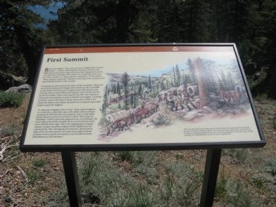
A staging area was set up at the base of the mountain. All goods were removed from the wagon and carried up the mountain on the backs of the people. Using several yoke of oxen and putting a man at each wheel, the wagons were slowly moved up the mountain. Upon reaching the top, the oxen and men returned to the bottom to assist with the next wagon. Looking carefully, scars at the base of some trees a few yards to the south can still be seen where pioneers wrapped ropes and chains to pull the wagons.
Dr. Edwards Tompkins writes in 1850: “A few miles brought us to a small lake, called Red Lake, in the midst of the mountains overhung by thick branches of evergreens. Two or three miles further found us at the foot of what is called “Three Quarter Mountain,” which is generally supposed to be, on reaching it, the main ridge of the Sierra Nevada, but it is several hundred feet lower that the main ridge. This is the stopping place of many wagons, owing to the great steepness, and irregularity of the mountainside. The road zigzags from the foot, obstructed by huge stones, for three quarter of a mile at an angle of about 45 degrees where it gains the summit, covered with immense embankments of eternal snow."
The route through Carson Pass and over First & Second Summits was known by the pioneers as the Carson River Route. It carried more gold seekers than any other Trail. In 1849 it is estimated that between 25,000 and 45,000 people traveled this route. In 1850 and 1852, it is estimated that 50,000 or more used this trail.
Erected by Oregon & California Trails Association CA/NV Chapter, El Dorado National Forest and National Park Service.
Topics and series. This historical marker is listed in these topic lists: Notable Places • Roads & Vehicles • Settlements & Settlers. In addition, it is included in the California Trail series list. A significant historical year for this entry is 1850.
Location. 38° 41.551′ N, 119° 59.142′ W. Marker is in Kirkwood, California, in Alpine County. Marker is on "Additional Parking" Road near Carson Pass Scenic Byway (California Highway 88).
Marker is located at the end of the "Addional Parking" Road east of the Kit Carson Visitors Center. This is a fee area. Touch for map. Marker is in this post office area: Kirkwood CA 95646, United States of America. Touch for directions.
Other nearby markers. At least 8 other markers are within 4 miles of this marker, measured as the crow flies. Carson Trail - Ascent to Carson Pass (about 500 feet away, measured in a direct line); Memorial to Pioneer Odd Fellows (about 500 feet away); Kit Carson (about 700 feet away); Naming of Carson Pass (about 700 feet away); Snowshoe Thom(p)son (about 700 feet away); The Emigrant Trail (approx. 0.2 miles away); Summer Retreat (approx. 3.2 miles away); Caples Lake (approx. 3.8 miles away). Touch for a list and map of all markers in Kirkwood.
Additional commentary.
1. From Trails West – Markers of the California Trail
Source:http://www.emigranttrailswest.org/caltrail.htm
CARSON TRAIL (1848)
In order to avoid the rigors of the Truckee Trail on their return to Salt Lake City, a group of Mormons, most of whom were former members of the disbanded Mormon Battalion, pioneered a new wagon trail to the Carson River. Beginning at Pleasant Valley, east of what would become Placerville, they followed ridges to the crest of the Sierra Nevada and then made their way through Carson Pass and along the Carson River to a point near modern Fallon, Nevada. From there they struck northwest to the bend in the Truckee River, where they joined the main California Trail.
As they headed east along the Humboldt River, the Mormon group met Joseph Chiles, again leading an emigrant train west, and informed him of their new wagon trail. Having been on the Carson River with the earlier Bidwell-Bartleson party, Chiles decided to turn southwest at the Humboldt Sink and blaze a wagon trail over the Forty Mile Desert to the Carson River. He reached the river about where the Mormon group had left it for the Truckee River, a place during the Gold Rush known as "Rag Town." This final link across the Forty Mile Desert completed the opening of the important Carson Trail to the gold fields.
— Submitted July 31, 2009, by Syd Whittle of Mesa, Arizona.
Additional keywords. Gold Rush
Credits. This page was last revised on March 19, 2021. It was originally submitted on July 31, 2009, by Syd Whittle of Mesa, Arizona. This page has been viewed 2,292 times since then and 72 times this year. Photos: 1, 2, 3, 4. submitted on July 31, 2009, by Syd Whittle of Mesa, Arizona.
Editor’s want-list for this marker. Photo of trees with scars as mentioned in marker text. • Can you help?


