Janesville in Rock County, Wisconsin — The American Midwest (Great Lakes)
The Black Hawk War / Black Hawk's Grove
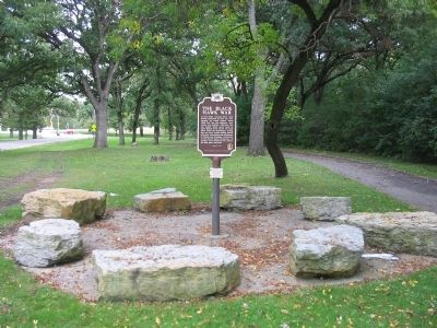
The Black Hawk War
In April 1832, unhappy about their forced relocation to Iowa and misadvised by tribal chiefs, about 1,000 Sac, Fox and Kickapoo men, women and children followed Sac war leader Black Hawk back to their Illinois home where the Rock River meets the Mississippi. During May and June, Indian raiding parties attacked homesteads and settlements in Illinois and Michigan territories. At the May 21 Indian Creek raid, 13 settlers were killed and two sisters, the Hall girls captured.
Black Hawk’s Grove
According to local tradition, Black Hawk’s band went north up the Rock River, camping several days here at Spring Brook Creek and giving the Hall girls to Winnebago Indians who later ransomed them to settlers. Pursued by General Henry Atkinson’s troops, Black Hawk continued north, then west to cross the Mississippi, but most of the Indians drowned or were killed by troops in August at the Battle of Bad Axe. Three years later, Janesville settlers found the remains of Indian tent poles and campfires and called this place Black Hawk’s Grove.
Erected 2001 by the State Historical Society of Wisconsin. (Marker Number 462.)
Topics and series. This historical marker is listed in this topic list: Wars, US Indian . In addition, it is included in the Black Hawk War, and the Wisconsin Historical Society series lists. A significant historical month for this entry is April 1832.
Location. 42° 40.46′ N, 88° 59.675′ W. Marker is in Janesville, Wisconsin, in Rock County. Marker is on Palmer Drive, 0.1 miles west of East Racine Street (U.S. 14), on the left when traveling west. Marker is east of the Blackhawk Golf Course parking lot. Touch for map. Marker is at or near this postal address: 2100 Palmer Drive, Janesville WI 53545, United States of America. Touch for directions.
Other nearby markers. At least 8 other markers are within 6 miles of this marker, measured as the crow flies. Burr Robbins Circus (approx. one mile away); First State Fair (approx. 1.3 miles away); Abraham Lincoln (approx. 1.7 miles away); First Congregational Church (approx. 1.7 miles away); Janesville Tank Company (approx. 1.7 miles away); James E. Croft (approx. 2.2 miles away); La Prairie Grange Hall (approx. 3.9 miles away); Route of Abraham Lincoln (approx. 5.7 miles away). Touch for a list and map of all markers in Janesville.
Also see . . . Black Hawk. Wikipedia entry. (Submitted on September 26, 2009.)
Credits. This page was last revised on June 16, 2016. It was originally submitted on September 26, 2009, by Keith L of Wisconsin Rapids, Wisconsin. This page has been viewed 6,660 times since then and 138 times this year. Photos: 1, 2, 3. submitted on September 26, 2009, by Keith L of Wisconsin Rapids, Wisconsin. • Craig Swain was the editor who published this page.
![The Black Hawk War Marker <i>[west side]</i>. Click for full size. The Black Hawk War Marker <i>[west side]</i> image. Click for full size.](Photos/78/Photo78555.jpg?11252005)
![Black Hawk's Grove Marker <i>[east side]</i>. Click for full size. Black Hawk's Grove Marker <i>[east side]</i> image. Click for full size.](Photos/78/Photo78556.jpg?11252005)
