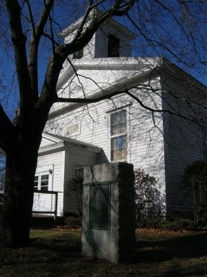
Colonie in Albany County, New York — The American Northeast (Mid-Atlantic)
The Boght
Settled On and After
1704 By The
Vischer Weaver Witbeck
Lansing Powell Runkle
Dunsbach Lieverse Staats
Roff Godfrey Van O Linde
Groesbeck Van Vranken Fero
Van De Mark Van Denburgh
Johnson Pollock Storms
Fonda and Clute Families
The Boght was part of the
Van O Linde Grant of Land
Given by the Mohawk Indinans
1667 to Hilletje Van Olinde
Interpertress
Of the Province
The Highway In Front Is The
Old Manor Road Northern
Boundary Line of The Manor
Of Rensselaerswyck
Erected by The State of New York And
The Cohoes Historical Society 1929
Erected 1929 by The State of New York and The Cohoes Historical Society.
Topics. This historical marker is listed in these topic lists: Churches & Religion • Colonial Era • Settlements & Settlers. A significant historical year for this entry is 1704.
Location. 42° 47.022′ N, 73° 44.407′ W. Marker is in Colonie, New York, in Albany County. Marker is on Boght Road (New York State Route 9R), on the right when traveling west. Touch for map. Marker is at or near this postal address: 583 Boght Road, Cohoes NY 12047, United States of America. Touch for directions.
Other nearby markers. At least 8 other markers are within 2 miles of this marker, measured as the crow flies. Boght Church (a few steps from this marker); James “Buttermilk” Lansing (approx. 1.2 miles away); Gen. Henry Knox Trail (approx. 1.3 miles away); Vandenburgh Dunsbach Ferry (approx. 1.4 miles away); Sightseeing / Cataract House, Cohoes Falls, N.Y. (approx. 1.6 miles away); Misty 17 (approx. 1.6 miles away); A Park Named Craner * Cohoes Recalls a Hero (approx. 1.6 miles away); Cohoes Tribute (approx. 1.7 miles away). Touch for a list and map of all markers in Colonie.
Additional keywords. Church of the Boght, Hilletje Van Olinda
Credits. This page was last revised on November 25, 2019. It was originally submitted on November 22, 2009, by Howard C. Ohlhous of Duanesburg, New York. This page has been viewed 1,374 times since then and 37 times this year. Photos: 1, 2, 3. submitted on November 22, 2009, by Howard C. Ohlhous of Duanesburg, New York. • Syd Whittle was the editor who published this page.


