Near Mechanicsburg in Hampshire County, West Virginia — The American South (Appalachia)
Interior of the Central Redoubt
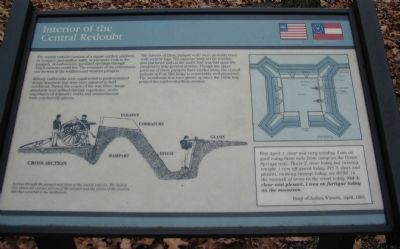
Military earthworks were constructed to predetermined design standards that were adjusted to field conditions. During the course of the war, these design standards were refined through experience, as the importance of defensive works and entrenchments were conclusively proven.
The interior of these parapet walls were probably lined with vertical logs. The cannons were set on wooden gun platforms liad on the earth. Sod was laid upon the parapets to help prevent erosion. Though the upper portions of these parapets have eroded away, the central redoubt at Fort Mill Ridge is remarkably well-preserved. The woodlands that have grown up since the 1860s help protect the earthworks from erosion.
Wed April 1. clear and vaary winday. I am on gard today three mils from camp on the Grean Springs rode. Thurs 2. clear today but raining tonight. i com off guard today. Fri 3. clear and plesant. nuthing strange today. we drilld in the manuell of arms in the street today. Sat 4. clear and plesant. i was on furtigue today on the mountain.
Diary of Joshua Winters, April 1863.
Topics. This historical marker is listed in these topic lists: Forts and Castles • War, US Civil. A significant historical month for this entry is April 1888.
Location. 39° 19.432′ N, 78° 47.615′ W. Marker is near Mechanicsburg, West Virginia, in Hampshire County. Marker can be reached from Fort Mill Ridge Park Road, on the right when traveling east. Located at trail stop 4 on the tour of Fort Mill Ridge Park. Touch for map. Marker is in this post office area: Burlington WV 26710, United States of America. Touch for directions.
Other nearby markers. At least 8 other markers are within walking distance of this marker. The Central Redoubt (a few steps from this marker); Control of the Mechanicsburg Gap (within shouting distance of this marker); An Outpost in Enemy Territory (within shouting distance of this marker); Construction of Fort Mill Ridge (within shouting distance of this marker); Engagement with McNeill's Rangers (within shouting distance of this marker); The Civil War in the South Branch Valley (within shouting distance of this marker); Fort Mill Ridge (about 300 feet away, measured in a direct line); Abandonment of Fort Mill Ridge (about 300 feet away). Touch for a list and map of all markers in Mechanicsburg.
More about this marker. On the lower left is a profile of a Civil War fortifications with important components of the structure indicated. The profile is captioned: Section through the parapet and ditch of the central redoubt. The dashed line shows the current section of the parapet and the extent of the erosion that has occurred to the earthworks. To the right is a plan of the central redoubt.
Credits. This page was last revised on November 5, 2020. It was originally submitted on December 9, 2009, by Craig Swain of Leesburg, Virginia. This page has been viewed 990 times since then and 11 times this year. Photos: 1. submitted on December 9, 2009, by Craig Swain of Leesburg, Virginia. 2. submitted on November 4, 2020, by Bradley Owen of Morgantown, West Virginia. 3. submitted on December 9, 2009, by Craig Swain of Leesburg, Virginia.


