Fredericksburg, Virginia — The American South (Mid-Atlantic)
The “Demon of Destruction”
Fredericksburg and Spotsylvania National Military Park
— National Park Service —
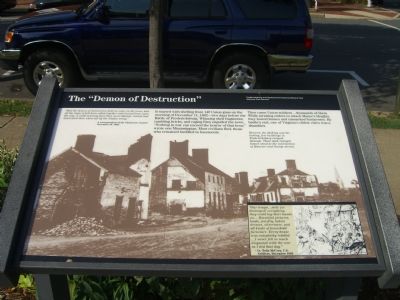
Had the demon of destruction held an orgie in the town, had all the imps of hell been called together and turned loose upon the city, it could scarcely have been more blasted, ruined and desecrated than when left by the Yankee army.”
—A correspondent of the Charleston Courier, December 16, 1862
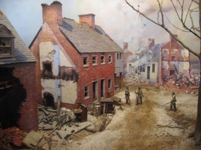
It started with shelling from 140 Union guns on the morning of December 11, 1862—two days before the Battle of Fredericksburg. Whizzing shell fragments, tumbling bricks, and raging fires engulfed the town. “Nothing in war can exceed the horror of that hour,” wrote one Mississippian. Most civilians fled; those who remained huddled in basements.
Then came Union soldiers…thousands of them. While awaiting orders to attack Marye’s Heights, they looted homes and ransacked businesses. By battle’s end, one of Virginia’s oldest cities was a shambles.
Between the shelling and the looting, few buildings in Fredericksburg escaped damage. These shell-ravaged homes stood at the intersection of Hanover and George Street.
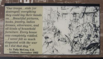
(Caption for picture in lower right) ”Our troops…stole [or destroyed] everything they could lay their hands on…Beautiful pictures, books, jewelry, ladies dresses, silverware, and all kinds of household furniture. Every house was completely riddled. …I never felt so much disgusted with the war as I did that day.”
—Lt. Tully McCrea, U.S. Artillery, December 1862
Erected by National Park Service, U.S. Department of the Interior.
Topics. This historical marker is listed in this topic list: War, US Civil. A significant historical month for this entry is December 1864.
Location. This marker has been replaced by another marker nearby. It was located near 38° 18.137′ N, 77° 27.594′ W. Marker was in Fredericksburg, Virginia. Marker was at the intersection of Princess Anne Street and George Street, on the left when traveling south on Princess Anne Street. Touch for map. Marker was at or near this postal address: 815 Princess Anne St, Fredericksburg VA 22401, United States of America. Touch for directions.
Other nearby markers. At least 10 other markers are within walking distance of this location. War Comes to Fredericksburg (here, next to this marker); A Sacked and Gutted Town (here, next to this marker); Gen. Stonewall Jackson (a few steps from this marker); A Vast Hospital (a few steps from this marker); The Court House (a few steps from this marker); In Memory of Clara Barton (within shouting distance of this marker); 1910 (within shouting distance of this marker); Great Exodus From Bondage (within shouting distance of this marker); 1833 (within shouting distance of this marker); Corporation Court House (within shouting distance of this marker). Touch for a list and map of all markers in Fredericksburg.
Related marker. Click here for another marker that is related to this marker. This marker has been replaced by the linked marker.
Also see . . . Ravaged Town. Another marker about Fredericksburg's destruction during the Civil War. (Submitted on September 19, 2007, by Kevin W. of Stafford, Virginia.)
Credits. This page was last revised on April 22, 2024. It was originally submitted on September 19, 2007, by Kevin W. of Stafford, Virginia. This page has been viewed 1,759 times since then and 17 times this year. Photos: 1, 2, 3. submitted on September 19, 2007, by Kevin W. of Stafford, Virginia. 4. submitted on December 14, 2008, by Craig Swain of Leesburg, Virginia. 5. submitted on December 15, 2008, by Craig Swain of Leesburg, Virginia. • J. J. Prats was the editor who published this page.
