Near Chester Gap in Rappahannock County, Virginia — The American South (Mid-Atlantic)
Chester Gap
Gateway to the Shenandoah Valley
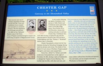
In the months following the Battle of Antietam in the autumn of 1862, Federal and Confederate armies sparred for control of the Blue Ridge passes. From October 28 to mid-November, intense skirmishing took place in and near Chester Gap. Confederate Gen. D.H. Hill’s division occupied the gap and also demonstrated at Thornton Gap until moving to Fredericksburg with Gen. Thomas J. “Stonewall” Jackson later in November.
Chester Gap played a critical role for Confederates during the Gettysburg Campaign during both the advance and retreat. Two-thirds of Gen. Robert E. Lee’s Army of Northern Virginia passed through it, and many units camped here.
Union Gen. Alfred T.A. Torbert and 5,000 cavalrymen bivouacked here on the night of December 19, 1864, during a raid on Gordonsville to disrupt the Virginia Central Railway. The weather was horrible, with sleet and rain, and many soldiers suffered from frostbite and exposure. The raid failed and the troopers returned to Winchester on December 28.
“This morning an army [Bank’s] is passing again. … Yesterday they did not disturb us much, came in several of them and wanted something to eat. 3 dined with us, two of which were sick. This morning they have made up for the good behavior of those yesterday … they drank up all the milk in the spring house, and took some of Pa’s hay this morning, they have been all over the yard, in the spring house, in the meadow, up the Cherrie trees, almost broke them to the ground [and have] been in the ice house, in the kitchen for something to eat, in the garden pulling out the currants, onions etc., so that we had to get a guard, in fact they have been doing everything in their power it seems to annoy us.” — Annie Chunn Gardner, girl living nearby at Mountain Home, diary, July 7, 1862 Courtesy Warren Heritage Society
Erected by Virginia Civil War Trails.
Topics and series. This historical marker is listed in this topic list: War, US Civil. In addition, it is included in the Virginia Civil War Trails series list. A significant historical year for this entry is 1862.
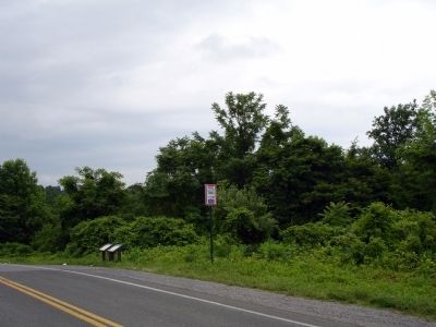
Location. 38° 51.717′ N, 78° 7.905′ W. Marker is near Chester Gap, Virginia, in Rappahannock County. Marker is on Chester Gap Road, on the left when traveling south. The marker is located Route 665 near its northern intersection with Route 522. Touch for map. Marker is in this post office area: Chester Gap VA 22623, United States of America. Touch for directions.
Other nearby markers. At least 8 other markers are within 5 miles of this marker, measured as the crow flies. Minding the Gaps (here, next to this marker); Warren County / Rappahannock County (within shouting distance of this marker); Gettysburg Campaign (within shouting distance of this marker); Albert G. Willis (approx. 1.7 miles away); Battle of Manassas Gap (approx. 3.9 miles away); No Park is an Island (approx. 4.2 miles away); The Massanutten (approx. 4.2 miles away); Camp Dismal Hollow (approx. 4.2 miles away). Touch for a list and map of all markers in Chester Gap.
More about this marker. On the lower left of the marker is a drawing captioned Banks crossing Chester Gap, drawing by Edwin Forbes Courtesy Library of Congres. On the upper middle of the marker are two photos captioned Gen. Nathaniel Banks Courtesy Library of Congres and Gen. Alfred T.A. Torbert Courtesy Library of Congres.
Credits. This page was last revised on June 16, 2016. It was originally submitted on June 20, 2010. This page has been viewed 2,246 times since then and 67 times this year. Photos: 1, 2. submitted on June 21, 2010. • Craig Swain was the editor who published this page.

