Henrico in Henrico County, Virginia — The American South (Mid-Atlantic)
Hopeless Attacks
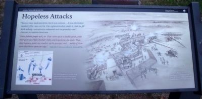
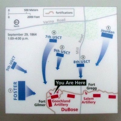
"Those fellows fought well, sir. They came up at a double quick, with their guns at a right shoulder shift, and leaped into the ditch. Then they began to assist one another up the parapet and...many of them were shot down upon the edge." Unidentified Confederate artillerist in Richmond Whig
Erected by Richmond National Battlefield Park.
Topics. This historical marker is listed in these topic lists: African Americans • Forts and Castles • War, US Civil. A significant historical date for this entry is September 29, 1864.
Location. 37° 26.821′ N, 77° 22.808′ W. Marker is in Henrico, Virginia, in Henrico County. Marker can be reached from Battlefield Park Road, 0.3 miles north of Mill Road. Touch for map. Marker is in this post office area: Henrico VA 23231, United States of America. Touch for directions.
Other nearby markers. At least 8 other markers are within 2 miles of this marker, measured as the crow flies. Fort Gilmer (here, next to this marker); Richmond Defences (approx. ¼ mile away); a different marker also named Fort Gilmer (approx. 0.7 miles away); Fort Harrison (approx. 0.7 miles away); First Successful Colonial Tobacco Crop (approx. ¾ mile away); Fort Johnson (approx. 0.8 miles away); Advancing On Richmond (approx. 0.8 miles away); Henrico Parish Church (approx. 1.2 miles away). Touch for a list and map of all markers in Henrico.
More about this marker. On the right is drawing with the caption, "The Union attackers had no advantages here. Confederates cut down all trees, providing a deadly field of fire for their artillery and infantry."
Related marker. Click here for another marker that is related to this marker. Old Marker At This Location also titled "Black Troops Attack at Chaffin’s Farm".
Also see . . . Richmond National Battlefield Park. (Submitted on July 12, 2010.)
Credits. This page was last revised on November 5, 2021. It was originally submitted on July 12, 2010, by Bernard Fisher of Richmond, Virginia. This page has been viewed 1,011 times since then and 30 times this year. Photos: 1, 2, 3. submitted on July 12, 2010, by Bernard Fisher of Richmond, Virginia. 4. submitted on August 21, 2010, by Craig Swain of Leesburg, Virginia.


