Near Four Oaks in Johnston County, North Carolina — The American South (South Atlantic)
Bentonville Battlefield Driving Tour
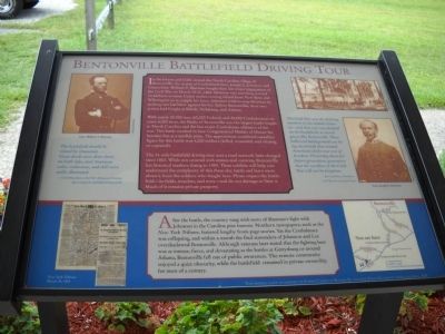
With nearly 80,000 men (60,000 Federals and 20,000 Confederates) on some 6,000 acres, the Battle of Bentonville was the largest battle fought in North Carolina and the last major Confederate offensive of the war. The battle resulted in four Congressional Medals of Honor for heroism but at a terrible price. The approximate combined casualties figure for this battle was 4,200 soldiers (killed, wounded, and missing or captured).
The 14-mile battlefield driving tour uses a road network little changed since 1865. While not covered with statues and cannons, Bentonville has historic markers dating to 1959. These exhibits will help you understand the complexity of this three-day battle and learn more about it from the soldiers who fought here. Please respect the battlefield – its fields, trenches, and trees – and do not damage or litter it. Much of it remains private property.
“The battlefield should be visited by thousands . . . . Great deeds were done there, on both sides, and American valor, endurance, and skill were nobly illustrated.”
- Fred Olds, father of the N.C. Museum of History, after touring the battlefield of Bentonville
“The Civil War was the defining moment in our nation’s history – and that war was decided on the battlefield, at sacred places like Bentonville. These hallowed battlegrounds are living memorials that remind Americans of the true cost of freedom. Preserving them for future generations guarantees that the sacrifices of the Civil War will not be forgotten.”
Jim Lighthizer, President, Civil War Preservation Trust
After the battle, the country rang with news of Sherman’s fight with Johnston in the Carolina pine barrens. Northern newspapers, such as the New York Tribune, featured lengthy front-page stories. Yet the Confederacy was collapsing, and within a month the final surrenders of Johnston and Lee overshadowed Bentonville. Although veterans later stated that the fighting here was as intense, fierce, and devastating as the battles at Gettysburg or around Atlanta, Bentonville fell out of public awareness. The remote community enjoyed a quiet obscurity, while the battlefield remained in private ownership for most of a century.
Erected 2004.
Topics. This historical marker is listed in this topic list: War, US Civil. A significant historical month for this entry is March 1865.
Location. 35° 18.124′ N, 78° 19.341′ W. Marker is near Four Oaks, North Carolina, in Johnston County. Marker is on Harper House Road, 0.1 miles west of Mill Creek Church Road, on the left when traveling east. The marker is located at the Bentonville Battlefield Visitor Center. Touch for map. Marker is at or near this postal address: 5466 Harper House Rd, Four Oaks NC 27524, United States of America. Touch for directions.
Other nearby markers. At least 8 other markers are within walking distance of this marker. Bentonville Battlefield (a few steps from this marker); Battle of Bentonville (a few steps from this marker); Confederate Hospital (within shouting distance of this marker); Union Hospital (about 300 feet away, measured in a direct line); Union Headquarters (about 300 feet away); North Carolinians at the Battle of Bentonville (about 300 feet away); North Carolina Monument (about 500 feet away); Texas (about 500 feet away). Touch for a list and map of all markers in Four Oaks.
More about this marker. Photos of Gen. William T. Sherman and Gen. Joseph E. Johnston, courtesy of the National Archives, appear on each side of the marker. The upper right of the marker features a picture of Sherman’s March from Harper’s Weekly. The bottom of marker contains a copy of the March 24, 1865 New York Tribune article about the Battle of Bentonville, and a map of the Bentonville Battlefield Driving Tour indicating the location of the marker, Harper House, Visitor Center and Cemetery.
Related markers. Click here for a list of markers that are related to this marker. Take a tour of the Roadside Exhibits erected on the Battle of Bentonville.
Also see . . . Battle of Bentonville ... the largest land battle ever fought in North Carolina. A detailed synopsis of the Battle of Bentonville. (Submitted on August 13, 2010, by Bill Coughlin of Woodland Park, New Jersey.)
Credits. This page was last revised on May 13, 2023. It was originally submitted on August 13, 2010. This page has been viewed 1,698 times since then and 51 times this year. Last updated on May 9, 2023. Photos: 1, 2, 3, 4. submitted on August 13, 2010, by Bill Coughlin of Woodland Park, New Jersey. • J. Makali Bruton was the editor who published this page.


