Mossy in Fayette County, West Virginia — The American South (Appalachia)
The Rebirth of Paint Creek
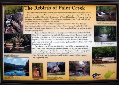
The coal boom did not come without consequences, however. Acid mine drainage from the mines and debris from coal camps polluted Paint Creek and depleted the fish population. For many years, the waters of Paint Creek turned red from the outflow of acidic water from nearby mines.
As the coal boom subsided and mining activity diminished in the watershed, Paint Creek began to slowly heal with the passage of time. However, much work remained to be done. In 1995, concerned citizens along Paint Creek joined together to Form the Upper and Lower Paint Creek Watershed Associations. After years of tireless work to improve water quality and fish habitat, Paint Creek is experiencing a rebirth.
Paint Creek now offers some of the best trout fishing opportunities in the area. Paint Creek is regularly stocked with trout, and anglers have become a common sight along the banks of the creek. Fishing has also become a popular activity at nearby Plum Orchard Lake. Located five miles north of Pax, Plum Orchard Lake entices anglers with sunfish, channel cattish, crappie, and largemouth bass.
Erected by Paint Creek Scenic Trail.
Topics. This historical marker is listed in these topic lists: Environment • Industry & Commerce. A significant historical year for this entry is 1852.
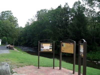
Location. 37° 58.536′ N, 81° 17.002′ W. Marker is in Mossy, West Virginia, in Fayette County. Marker is at the intersection of Bishop Ranch (West Virginia Route 612) and Milburn Road (County Route 1/5), on the right when traveling east on Bishop Ranch. Touch for map. Marker is in this post office area: Scarbro WV 25917, United States of America. Touch for directions.
Other nearby markers. At least 8 other markers are within 7 miles of this marker, measured as the crow flies. Mossy (here, next to this marker); Coal Camp History (a few steps from this marker); Oakwood Mine Complex (approx. 5.1 miles away); William S. Dunbar (approx. 6.2 miles away); The White Oak Valley (approx. 6½ miles away); Labor Strikes and Conflicts (approx. 6½ miles away); Disaster Underground (approx. 6½ miles away); The Coal Barons (approx. 6½ miles away). Touch for a list and map of all markers in Mossy.
More about this marker. On the upper left are photos with the caption, “Scenic views and waterfalls are some of Paint Creek’s hidden treasure.” Photos by Cristina Butler
On the lower left is a photo with the caption, “Open to fishing in 1963, Plum Orchard Lake has a multitude of attractions to offer.” Photo by Ronn Raszetnik
On the bottom center are photos with the captions; “Whitetail deer.”, “Laurel Grove Missionary Baptist Church lies along the scenic roads of Paint Creek Trail.”, “Beautiful scenic areas are plentiful along the Paint Creek Trail.” Photos by Henry Meredith
On the upper right is a photo with the caption, “Many enjoy fishing along Paint Creek.” Photo by Ernie Nester
On the middle right is a photo with the caption, “Areas of the trail can take your memories to a simpler time with its beauty and simplicity." Photo by Cristina Butler
On the lower right is a photo with the caption, “Many magnificent waterfalls are found along the scenic creek.” Photo by Ronn Raszetnik
Also see . . . Paint Creek Scenic Trails. (Submitted on August 15, 2010.)
Credits. This page was last revised on November 14, 2021. It was originally submitted on August 15, 2010, by Bernard Fisher of Richmond, Virginia. This page has been viewed 1,392 times since then and 89 times this year. Photos: 1, 2, 3. submitted on August 15, 2010, by Bernard Fisher of Richmond, Virginia.


