Near Warrenton in Fauquier County, Virginia — The American South (Mid-Atlantic)
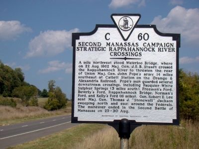
Second Manassas Campaign
Strategic Rappahannock River Crossings
Erected 1997 by Department of Historic Resources. (Marker Number C-60.)
Topics and series. This historical marker is listed in this topic list: War, US Civil. In addition, it is included in the Virginia Department of Historic Resources (DHR) series list. A significant historical date for this entry is August 22, 1862.
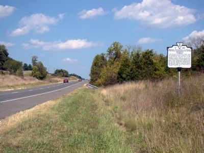
Location. 38° 41.117′ N, 77° 54.083′ W. Marker is near Warrenton, Virginia, in Fauquier County. Marker is on Lee Highway (U.S. 211) west of Leeds Manor Road / Harts Mill Road (County Route 688), on the right when traveling east. Marker cannot be seen from the westbound lanes because of a wide, treed median. Touch for map. Marker is in this post office area: Warrenton VA 20186, United States of America. Touch for directions.
Other nearby markers. At least 8 other markers are within 6 miles of this marker, measured as the crow flies. Waterloo Bridge (approx. ¾ mile away); Campaign of Second Manassas (approx. 1.1 miles away); Ashland Farm (approx. 2 miles away); a different marker also named Second Manassas Campaign (approx. 2 miles away); Culpeper County / Rappahannock County (approx. 3.9 miles away); a different marker also named Campaign of Second Manassas (approx. 4 miles away); Eliza Brown and the Custers (approx. 5.2 miles away); Corbin's Crossroads (approx. 5.2 miles away). Touch for a list and map of all markers in Warrenton.
More about this marker. This marker replaced a marker from the 1930s with the same number titled “Campaign of Second Manassas” that read “About two miles north is Waterloo Bridge, where J. E. B. Stuart began his raid to Catlett’s Station in the rear of Pope’s army, August 22, 1862. Some miles farther north is Hinson’s Mill, where Stonewall Jackson crossed this river, August 25, 1862, on the march around Pope that resulted in the Second Battle of Manassas.”
Credits. This page was last revised on June 16, 2016. It was originally submitted on October 10, 2010, by J. J. Prats of Powell, Ohio. This page has been viewed 1,558 times since then and 25 times this year. Photos: 1, 2. submitted on October 10, 2010, by J. J. Prats of Powell, Ohio. 3. submitted on May 16, 2008, by Craig Swain of Leesburg, Virginia. • Craig Swain was the editor who published this page.


