Near Gardiner in Park County, Montana — The American West (Mountains)
Yellowstone's Northern Range
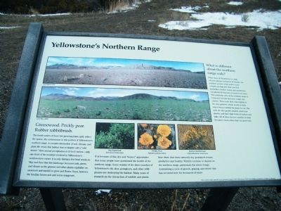
While most of Yellowstone is a high volcanic plateau composed of rhyolite, the northern portion of the park is more complex geologically. Here you find landslides, erodible shales and sandstones, and glacial till deposits of mixed rock types. This particular area of the northern range is composed of soils that have a high clay content. These soils bind water tightly to the clay particles, which results in little water being available for plants to use. The soils are also poorly aerated, resist root growth, and have high levels of sodium and salts. All of these factors combine to limit the plant communities that can grow here.
Greasewood. Prickly pear. Rubber rabbitbrush.
The harsh names of these low-growing plants aptly reflect the sparse, dry environment in this portion of Yellowstone's northern range. A complex interaction of soil, climate, and plant life create this habitat that ecologists call a "cold desert." Here annual precipitation is 10 to 15 inches - only one-third of the moisture received in Yellowstone's southwestern corner. It is only during a few brief weeks in May and June that this landscape becomes lush, green, and vibrant as the grasses and other plants capitalize on snowmelt and rainfall to grow and flower. Soon, however, the familiar brown and arid scene reappears.
It is because of this dry and "beaten" appearance that many people have questioned the health of the northern range. Some wonder if the sheer number of Yellowstone's elk, deer, pronghorn, and other wild grazers are destroying habitat. Many years of research on the interaction of wildlife and plants here show that these naturally dry grasslands remain productive and healthy. Wildlife continue to depend on the northern range, particularly for winter forage, maintaining a cycle of growth, grazing, and rebirth that has occurred here for thousands of years.
Erected by This exhibit made possible by a generous grant to the Yellowstone Park Foundation in memory of Katie L. Rhoads.
Topics. This historical marker is listed in these topic lists: Natural Features • Natural Resources.
Location. 45° 1.25′ N, 110° 41.795′ W. Marker is near Gardiner, Montana, in Park County. Marker is on North Entrance Road, 0.9 miles south of West Park Street, on the left when traveling south. 0.4 miles south of the official entrance (where you pay) to the park. Touch for map. Marker is in this post office area: Gardiner MT 59030, United States of America. Touch for directions.
Other nearby markers. At least 8 other markers are within 3 miles of this marker, measured as the crow flies. A Wildlife Paradise (here, next to this marker); Wildlife Migrations
(approx. ¼ mile away); Wildlife of the Northern Range (approx. 0.3 miles away); Serving Visitors Since the Beginning (approx. 0.8 miles away); Roosevelt Arch (approx. 0.9 miles away); Gardiner Jail (approx. 0.9 miles away); Boiling River Trail (approx. 2 miles away); Mt. Everts Mudslides (approx. 2.9 miles away in Wyoming). Touch for a list and map of all markers in Gardiner.
Credits. This page was last revised on June 16, 2016. It was originally submitted on February 27, 2011, by Rich Pfingsten of Forest Hill, Maryland. This page has been viewed 617 times since then and 14 times this year. Photos: 1, 2, 3. submitted on February 27, 2011, by Rich Pfingsten of Forest Hill, Maryland. • Bill Pfingsten was the editor who published this page.


