Wytheville in Wythe County, Virginia — The American South (Mid-Atlantic)
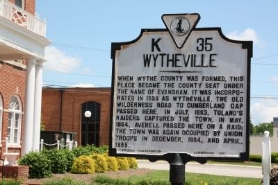
Wytheville
Erected 1941 by Virginia Conservation Commission. (Marker Number K-35.)
Topics and series. This historical marker is listed in these topic lists: Political Subdivisions • War, US Civil. In addition, it is included in the Virginia Department of Historic Resources (DHR) series list. A significant historical month for this entry is April 1865.
Location. 36° 57.02′ N, 81° 4.986′ W. Marker is in Wytheville, Virginia, in Wythe County. Marker is on East Main Street (U.S. 11) just west of 1st Street, on the right when traveling west. Touch for map. Marker is at or near this postal address: 170 E Main St, Wytheville VA 24382, United States of America. Touch for directions.
Other nearby markers. At least 8 other markers are within walking distance of this marker. Boone Trail Highway Memorial (here, next to this marker); Edith Bolling Wilson (within shouting distance of this marker); St. John's Episcopal Church (about 400 feet away, measured in a direct line); The Haller-Gibboney Rock House (about 400 feet away); Home Site of Christopher (Stophel) Simmerman (about 400 feet away); Welcome to the Thomas J. Boyd Museum (about 600 feet away); The Lynching of Raymond Byrd (about 800 feet away); LOVE (approx. 0.2 miles away). Touch for a list and map of all markers in Wytheville.

Photographed By J. J. Prats, May 28, 2011
3. Skeeter’s, Home of the Skeeter-Dog
The food at Skeeter’s across the street from this marker must be real good. I had already had lunch when I stopped here at half-past noon on Saturday to photograph this marker so I cannot say one way or another from personal experience, but locals were entering non-stop while others were driving off with bags of food.
Credits. This page was last revised on October 30, 2022. It was originally submitted on July 23, 2011, by J. J. Prats of Powell, Ohio. This page has been viewed 976 times since then and 46 times this year. Last updated on October 28, 2022, by Bradley Owen of Morgantown, West Virginia. Photos: 1, 2, 3. submitted on July 23, 2011, by J. J. Prats of Powell, Ohio. • Bernard Fisher was the editor who published this page.

