Deep Creek North in Chesapeake, Virginia — The American South (Mid-Atlantic)
Village of Deep Creek
The Dismal Swamp Rangers
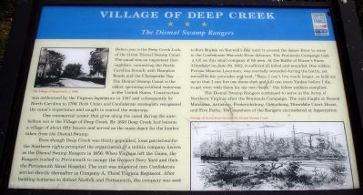
Before you is the Deep Creek Lock of the Great Dismal Swamp Canal. The canal was an important thoroughfare, connecting the North Carolina Sounds with Hampton Roads and the Chesapeake Bay. The Dismal Swamp Canal is the oldest operating artificial waterway in the United States. Construction was authorized by the Virginia legislature in 1787 and subsequently by North Carolina in 1790. Both Union and Confederate strategists recognized the canal’s importance and sought to control the waterway.
One commercial center that grew along the canal during the antebellum era is the Village of Deep Creek. By 1850 Deep Creek had become a village of about fifty houses and served as the main depot for lumber taken from the Dismal Swamp.
Even though Deep Creek was thinly populated, local patriotism for the Southern rights prompted the organization of a militia company known as the Dismal Swamp Rangers in 1856. When Virginia left the Union, the Rangers rushed to Portsmouth to occupy the Gosport Navy Yard and then the Portsmouth Naval Hospital. The unit was mustered into Confederate service shortly thereafter as Company A, Third Virginia Regiment. After taking batteries to defend Norfolk and Portsmouth, the company was sent to Fort Boykin on Burwell’s Bay until it crossed the James River to serve in the Confederate Warwick River defenses. The Peninsula Campaign took a toll on this small company of 68 men. At the Battle of Frazer’s Farm (Glendale) on June 30, 1862, it suffered 22 killed and wounded. One soldier, Private Maurice Liverman, was mortally wounded during the battle, yet turned to his comrades and said, “Boys, I can’t live much longer, so hold me up so that I can fire one more shot and kill one more Yankee before I die, to get even with them for my own death.” His fellow soldiers complied.
The Dismal Swamp Rangers continued to serve in the Army of Northern Virginia after the Peninsula Campaign. The unit fought at Second Manassas, Antietam, Fredericksburg, Gettysburg, Dinwiddie Court House, and Five Forks. Two members of the Rangers surrendered at Appomattox.
Erected by Virginia Civil War Trails.
Topics and series. This historical marker is listed in this topic list: War, US Civil. In addition, it is included in the Virginia Civil War Trails series list. A significant historical month for this entry is June 1818.
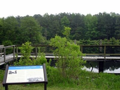
Location. This marker has been replaced by another marker nearby. It was located near 36° 44.762′ N, 76° 20.458′ W. Marker was in Chesapeake, Virginia. It was in Deep Creek North. Marker could be reached from Luray Street. The marker was located in Deep
Creek Lock Park. Touch for map. Marker was at or near this postal address: 300 Luray Street, Chesapeake VA 23323, United States of America. Touch for directions.
Other nearby markers. At least 8 other markers are within 5 miles of this location, measured as the crow flies. A different marker also named Village of Deep Creek (a few steps from this marker); Justin Holland (approx. 0.4 miles away); Owens-Melvin House (approx. 0.8 miles away); Cody S. Childers (approx. 2˝ miles away); Great Dismal Swamp National Wildlife Refuge (approx. 4.2 miles away); Site of the Nansemond Indian Public School #9 (approx. 4.2 miles away); Unknown and Known Afro-Union Civil War Soldiers Memorial (approx. 4.3 miles away); Dismal Swamp Canal Trail (approx. 4.4 miles away). Touch for a list and map of all markers in Chesapeake.
More about this marker. On the upper left was a photo captioned, "Village of Deep Creek, c. 1890." On the lower right was a sketch of the canal captioned, "Passage of Union boats through the Dismal Swamp Canal."
Related marker. Click here for another marker that is related to this marker. This marker has been replaced with the linked marker.
Also see . . .
1. History of the Dismal Swamp Rangers. (Submitted on January 16, 2008.)
2. PDF of the marker. (Submitted on April 15, 2008, by Christopher Busta-Peck of Shaker Heights, Ohio.)
Credits. This page was last revised on February 1, 2023. It was originally submitted on January 16, 2008. This page has been viewed 4,928 times since then and 109 times this year. Last updated on January 16, 2008. Photos: 1, 2. submitted on January 16, 2008. • Craig Swain was the editor who published this page.

