Mi-Wuk Village in Tuolumne County, California — The American West (Pacific Coastal)
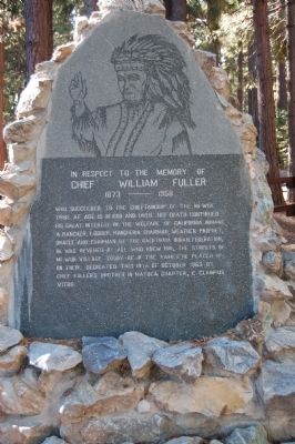
Chief William Fuller
In respect to the memory of Chief William Fuller
— 1873 – 1958 —
Erected 1963 by E Clampus Vitus, Matuca Chapter No. 1849.
Topics and series. This historical marker is listed in this topic list: Native Americans. In addition, it is included in the E Clampus Vitus series list. A significant historical date for this entry is October 19, 1963.
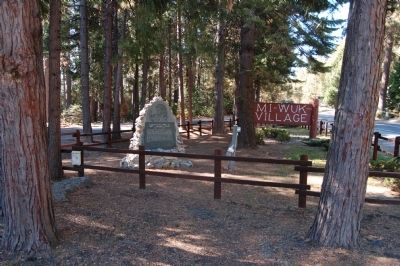
Location. 38° 3.991′ N, 120° 11.381′ W. Marker is in Mi-Wuk Village, California, in Tuolumne County. Marker is at the intersection of Sonora Pass Highway (State Highway 108) and Pela Road, on the left when traveling east on Sonora Pass Highway. The marker is in a small island formed by the Sonora Pass Highway, Pela Road and Pela Road Cut-off. Touch for map. Marker is in this post office area: Mi Wuk Village CA 95346, United States of America. Touch for directions.
Other nearby markers. At least 8 other markers are within 8 miles of this marker, measured as the crow flies. Sonora Pass – Mono Road (approx. 0.7 miles away); Confidence Mine (approx. 1.8 miles away); Bald Rock Ranch (approx. 2.9 miles away); Sonora Mono Road (approx. 3.3 miles away); Cherokee (approx. 6.8 miles away); Soulsbyville (approx. 6.9 miles away); a different marker also named Soulsbyville (approx. 7 miles away); The Joseph Lord House (approx. 7.1 miles away).
Also see . . . Chief Fuller Historical Monument. Chief Fuller was the son of Alfred Fuller, a white who had emigrated to California from Ohio in the 1850s by covered wagon. Chief Fuller's mother was Jenita, the only survivor of the previous Chief of the Mi Wuk (or Me Wuk) Indians. (Submitted on November 29, 2011.)
Credits. This page was last revised on June 16, 2016. It was originally submitted on November 27, 2011, by Barry Swackhamer of Brentwood, California. This page has been viewed 1,112 times since then and 39 times this year. Photos: 1, 2. submitted on November 27, 2011, by Barry Swackhamer of Brentwood, California. • Syd Whittle was the editor who published this page.

