Marker Logo HMdb.org THE HISTORICAL
MARKER DATABASE
“Bite-Size Bits of Local, National, and Global History”
Nichols in Marion County, South Carolina — The American South (South Atlantic)
 

Drowning Creek


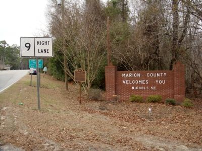
Drowning Creek Marker image. Click for full size.
Photographed By J. J. Prats, January 26, 2008
1. Drowning Creek Marker
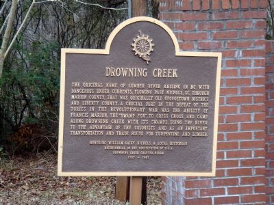
Inscription. Drowning Creek the original name of Lumber River arising in NC with dangerous undercurrents, flowing past Nichols, SC, through Marion County, that was originally old Georgetown District and Liberty County. A crucial part in the defeat of the Tories in the Revolutionary War was the ability of Francis Marion, the “Swamp Fox,” to crisscross and camp along Drowning Creek with it’s swamps, using the river to the advantage of the colonists and as an important transportation and trade route for turpentine and lumber.
 
Erected 1987 by Drowning Creek Chapter, Daughters of the American Revolution. Honoring William Gairy Nichols, a local Historian, and the Bicentennial of the Constitution of U.S.A.
 
Topics and series. This historical marker is listed in these topic lists: War, US RevolutionaryWaterways & Vessels. In addition, it is included in the Daughters of the American Revolution series list.
 
Location. 34° 13.682′ N, 79° 8.421′ W. Marker is in Nichols, South Carolina, in Marion County. Marker is on South Nichols Street (State Highway 9) east of Waccamaw Street, on the right when traveling west. Marker is at the Marion County – Horry County line. Touch for map. Marker is in this post office area: Nichols SC 29581, United States of America. Touch for directions.
 
Other nearby markers.
Paid Advertisement
Click on the ad for more information.
Please report objectionable advertising to the Editor.
Click or scan to see
this page online
At least 8 other markers are within 14 miles of this marker, measured as the crow flies. Mt. Olive Baptist Church (approx. 6.4 miles away); Tobacco Culture (approx. 6.7 miles away); Mullins Depot / Mullins (approx. 6.7 miles away); The Meeting House (approx. 8.3 miles away); Ford’s Mill & Page’s Mill / Lake View (approx. 8˝ miles away); Green Sea Baptist Church (approx. 11.7 miles away); Galivants Ferry Stump Meeting (approx. 13.3 miles away); Galivants Ferry (approx. 13.4 miles away).
 
Additional keywords. DAR
 
Drowning Creek Marker image. Click for full size.
Photographed By J. J. Prats, January 26, 2008
2. Drowning Creek Marker
Lumber River image. Click for full size.
Photographed By Anna Inbody, August 7, 2011
3. Lumber River
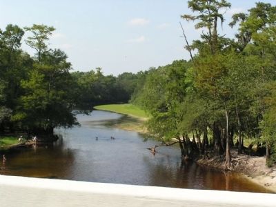
Originally known as Drowning Creek, this picture of the Lumber River was taken from the bridge just east of the marker.
Lumber River image. Click for full size.
Photographed By Anna Inbody, August 7, 2011
4. Lumber River
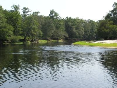
This view shows the dangerous currents and terrain that had to be traversed by Francis Marion.
 
 
Credits. This page was last revised on September 18, 2020. It was originally submitted on January 31, 2008, by J. J. Prats of Powell, Ohio. This page has been viewed 3,112 times since then and 171 times this year. Photos:   1, 2. submitted on January 31, 2008, by J. J. Prats of Powell, Ohio.   3, 4. submitted on August 10, 2011, by Anna Inbody of Columbia, South Carolina.
Share this page.  
Share on Tumblr
m=5085

CeraNet Cloud Computing sponsors the Historical Marker Database.
This website earns income from purchases you make after using our links to Amazon.com. We appreciate your support.
Paid Advertisements
Mar. 19, 2024