Near Glasgow in Beaver County, Pennsylvania — The American Northeast (Mid-Atlantic)
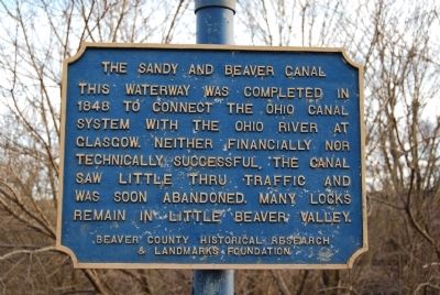
The Sandy and Beaver Canal
This waterway was completed in 1848 to connect the Ohio Canal System with the Ohio River at Glasgow. Neither financially or technically successful, the canal saw little thru traffic and was soon abandoned. Many locks remain in Little Beaver Valley.
Erected by Beaver County Historical Research and Landmarks Foundation.
Topics and series. This historical marker is listed in this topic list: Waterways & Vessels. In addition, it is included in the Pennsylvania - Beaver County Historical Research and Landmarks Foundation series list. A significant historical year for this entry is 1848.
Location. 40° 38.711′ N, 80° 30.698′ W. Marker is near Glasgow, Pennsylvania, in Beaver County. Marker is at the intersection of Midland Road (Pennsylvania Route 68) and Main Street, on the right when traveling east on Midland Road. Touch for map. Marker is in this post office area: Industry PA 15052, United States of America. Touch for directions.
Other nearby markers. At least 8 other markers are within walking distance of this marker. Beginning Point of the U. S. Public Land Survey (approx. 0.4 miles away in Ohio); The Point of Beginning (approx. 0.4 miles away); Down The Ohio (approx. 0.4 miles away); Gateway To The Northwest (approx. 0.4 miles away in Ohio); Land Ordinance of 1785 / The Seven Ranges (approx. 0.4 miles away in Ohio); Smiths Ferry (approx. half a mile away); Georgetown (approx. 0.7 miles away); a different marker also named Down The Ohio (approx. 0.7 miles away).
Also see . . .
1. Sandy and Beaver Canal. Wikipedia entry (Submitted on March 23, 2022, by Larry Gertner of New York, New York.)
2. Beaver County Historical Research and Landmarks Foundation. Foundation website homepage (Submitted on January 8, 2012, by Mike Wintermantel of Pittsburgh, Pennsylvania.)
Credits. This page was last revised on March 23, 2022. It was originally submitted on January 8, 2012, by Mike Wintermantel of Pittsburgh, Pennsylvania. This page has been viewed 1,050 times since then and 40 times this year. Photos: 1, 2, 3, 4. submitted on January 8, 2012, by Mike Wintermantel of Pittsburgh, Pennsylvania.


