West Hartford in Hartford County, Connecticut — The American Northeast (New England)
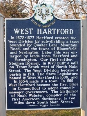
West Hartford
Connecticut Historical Commission
1970
Erected 1970 by Connecticut Historical Commission.
Topics. This historical marker is listed in these topic lists: Colonial Era • Settlements & Settlers. A significant historical year for this entry is 1679.
Location. 41° 45.736′ N, 72° 44.523′ W. Marker is in West Hartford, Connecticut, in Hartford County. Marker is at the intersection of North Main Street and Farmington Avenue, on the right when traveling south on North Main Street. Touch for map. Marker is in this post office area: West Hartford CT 06107, United States of America. Touch for directions.
Other nearby markers. At least 8 other markers are within walking distance of this marker. SS Maiden Creek (a few steps from this marker); Connecticut Veterans Memorial West Hartford (within shouting distance of this marker); Meeting House Corner (within shouting distance of this marker); First Public Library Building in West Hartford (within shouting distance of this marker); Goodman Green (within shouting distance of this marker); Webster Walk (about 700 feet away, measured in a direct line); a different marker also named Webster Walk (about 700 feet away); Korczak Ziolkowski (about 700 feet away). Touch for a list and map of all markers in West Hartford.
Also see . . .
1. West Hartford, Connecticut. Wikipedia entry (Submitted on March 10, 2012, by Michael Herrick of Southbury, Connecticut.)
2. West Hartford Historic Sites. City webpage (Submitted on December 21, 2020, by Larry Gertner of New York, New York.)
Credits. This page was last revised on December 21, 2020. It was originally submitted on March 10, 2012, by Michael Herrick of Southbury, Connecticut. This page has been viewed 714 times since then and 13 times this year. Photos: 1, 2. submitted on March 10, 2012, by Michael Herrick of Southbury, Connecticut.

