South Woodbury Township near Everett in Bedford County, Pennsylvania — The American Northeast (Mid-Atlantic)
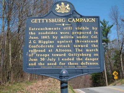
Gettysburg Campaign
Erected 1963 by Pennsylvania Historical and Museum Commission.
Topics and series. This historical marker is listed in this topic list: War, US Civil. In addition, it is included in the Pennsylvania Historical and Museum Commission series list. A significant historical month for this entry is June 1863.
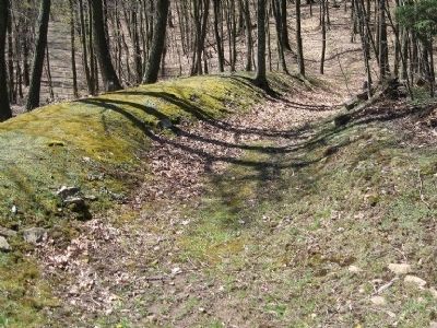
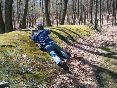
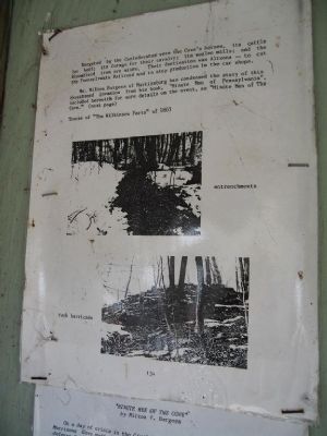
Location. 40° 6.05′ N, 78° 23.37′ W. Marker is near Everett, Pennsylvania, in Bedford County. It is in South Woodbury Township. Marker is on Upper Snake Spring Road (Pennsylvania Route 1005), on the right when traveling south. Approximately, entrenchments extend 120 yards westward and 85 yards eastward from the road and they are visible during Winter in satellite imagery. Near the western terminus at 40°6.004',-78°23.416', a second signpost contains detailed interpretive information. Touch for map. Marker is at or near this postal address: 4147 Church View Rd, New Enterprise PA 16664, United States of America. Touch for directions.
Other nearby markers. At least 8 other markers are within 7 miles of this marker, measured as the crow flies. Rural Electrification (approx. 4.9 miles away); Road Versus Rail (approx. 5.9 miles away); Our Main Street (approx. 6.2 miles away); Highway Enterprise (approx. 6.2 miles away); Early Roads (approx. 6.3 miles away); Transportation History (approx. 6.3 miles away); Everett Area Honor Roll (approx. 6.3 miles away); Everett Veterans Memorial (approx. 6.3 miles away). Touch for a list and map of all markers in Everett.
Regarding Gettysburg Campaign. Had Confederate General Robert E. Lee adopted a "scorched earth" strategy in Pennsylvania during late June of 1863, he would have encountered little resistance from a Union Army whose primary focus was defense of the U.S. capital. Perfect hindsight affords the conclusion that the railroad and iron-producing resources of central Pennsylvania were never effectively jeopardized by the Gettysburg Campaign, but at the time of the invasion, Lee's true motives and objectives were not obvious to Northerners. Furthermore, the Confederate Army detachment nearest to the railroad shops at Altoona was showing an unsettling penchant for the destruction of transportation-related infrastructure.
Confederate General John D. Imboden's "Northwestern Brigade" consisted of the combined 2,100 men and six cannons of the 18th Virginia Cavalry, 62nd Virginia Infantry, one company of the Virginia Partisan Rangers, and an artillery battery. During June, 1863, his Brigade had destroyed a half dozen bridges, rolling stock, depots, water tanks, and several blockhouses of the Baltimore and Ohio Railroad between Martinsburg, WV, and Cumberland, MD. It had also cut the Chesapeake and Ohio Canal in two places in Maryland and, within a short time after entering Pennsylvania, had become entirely mounted by benefit of the plunder of local horses. Once Imboden's Brigade was in Pennsylvania, its intentions became more limited-to act as a screen and to secure needed supplies for the remainder of General Robert E. Lee's Army of Northern Virginia.[1]
Knowing the destructive capabilities of the Northwestern Brigade but not its intentions, Major General Darius N. Couch (commanding the Department of the Susquehanna) requested Colonel Higgins to raise a regiment and Governor Andrew Curtin assigned him command of militia in southcentral Pennsylvania on June 16.[2] While his men hastily constructed makeshift forts in the mountain gaps, Higgins coordinated defense of the region with a fragment of General Robert H. Milroy's defeated Eight Corps, Second Division, who had retreated to Bloody Run after the Second Battle
of Winchester. Upon application, Higgins surrendered artillery to Milroy's men and loaned them a battalion under Lieutenant Jacob Szink for an expedition toward McConnellsburg.[3]
At McConnellsburg on June 29 the Northwestern Brigade sustained its first reverse. Company G of the 18th Virginia Cavalry, led by Captain William D. Erwin, was ambushed by Capt. Abram Jones' company of the 1st New York Cavalry from Milroy's Division, working with unarmed militia cavalrymen who created the appearance of a flanking attack. Fleeing town, Erwin's Cavalry was pursued and defeated in a saber duel.[4] Two Confederate men were killed (the first two C.S.A. soldiers to die in battle on Pennsylvania soil), and Erwin, Lieutenant Jordan, and twenty (or more) others were taken prisoner.[5]
Lee's orders were revealed by Imboden after the war:
"[Lee] ordered me to go into Pennsylvania as far as I deemed it prudent, west of North (Tuscarora) Mountain, and to keep an eye upon Milroy, who was reported to be collecting his scattered troops at Bloody Run."[6]
and expressed no geographic limitations. As Burgess interprets, "In this you see that General Imboden, while he had no specific order to move against Altoona, had the authority to do so, had he deemed it prudent."[7]
1. Spencer, Tucker (2002). Brigadier General John D. Imboden: Confederate commander in the Shenandoah.
Lexington, KY: The University Press of Kentucky. pp. 143-144. ISBN 978-0813122663.
2. Burgess, Milton V. (1962). Minute Men of Pennsylvania. Martinsburg, PA: Morrisons Cove Herald. pp. 5-7. ISBN ASIN: B0041SFOQM.
3. Burgess, Milton V. (1962). Minute Men of Pennsylvania. Martinsburg, PA: Morrisons Cove Herald. pp. 30,46. ISBN ASIN: B0041SFOQM.
4. ExplorePAHistory. "Confederate Dead [McConnellsburg Historical Marker"]. http://explorepahistory.com/hmarker.php?markerId=1-A-1E4. Retrieved 18 February 2012.
5. Spencer, Tucker (2002). Brigadier General John D. Imboden: Confederate commander in the Shenandoah. Lexington, KY: The University Press of Kentucky. pp. 146. ISBN 978-0813122663.
6. Imboden, J. D. (April 1871). "Lee at Gettysburg". The Galaxy. 4 XI: 508.
7. Burgess, Milton V. (1962). Minute Men of Pennsylvania. Martinsburg, PA: Morrisons Cove Herald. pp. 10. ISBN ASIN: B0041SFOQM.
Additional commentary.
1. Obscure Location; McConnelsburg Markers are related
Quite possibly, this marker is the farthest northwest with the title, "Gettysburg Campaign." The markers near McConnellsburg which describe the death of two Confederate soldiers are related to this marker, as are the soldier's grave markers.
— Submitted April
7, 2012, by Donald E Coho of York, Pennsylvania.
Credits. This page was last revised on February 7, 2023. It was originally submitted on April 7, 2012, by Donald E Coho of York, Pennsylvania. This page has been viewed 1,743 times since then and 99 times this year. Photos: 1, 2, 3, 4. submitted on April 7, 2012, by Donald E Coho of York, Pennsylvania. • Craig Swain was the editor who published this page.


