Newport in Newport County, Rhode Island — The American Northeast (New England)
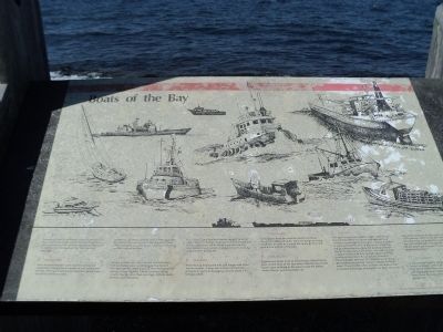
Boats of the Bay
1. Ferry
Increasing numbers of Rhode Islanders board cruise boats and ferries to get out of the Bay. These ferries are reminiscent of the pleasure steamboats that were so common on Narragansett Bay one hundred years ago.
2. Fast Frigate
Navy destroyer tenders carry sophisticated sonar equipment, making them capable of anti-submarine warfare. Their guns and missile launchers equip them for anti-air warfare as well.
3. Recreational Fishing Boat
Numerous sportfishing boats seen on Narragansett Bay reflect the productivity of these waters. Many other recreational power boats can be seen cruising the Bay in good weather.
4. Sloop
Sloops, such as this one, are very common here. The protected waters and sheltered harbors of Narragansett Bay make it one of the finest areas for sailing in New England. Other common sailing vessels, having more than one mast, include yawls, ketches, and schooners.
5. Coast Guard Boat
U.S. Coast Guard boats of various designs perform many duties in the Bay. Some are used for search and rescue operations, while other boats are used to maintain and repair aids to navigation such as buoy markers and lighthouses.
6. Tug Boat
Powerful tug boats push and pull barges and other marine vessels. A mop-like bumper at the bow prevents a tug from damaging a vessel while it is being pushed.
7. Quahog Skiff
Quahoggers work the shellfish beds from these sturdy flat-bottomed skiffs. They use tongs and long-handled bull rakes to unearth the quahogs from the mud at the bottom of the Bay.
8. Lobster Boat
Lobstermen lower lines of baited traps, called lobster pots, to the floor of the Bay where lobsters live. Small buoys seen bobbing in the waves mark the places where lobster pots have been set.
9. Research Vessels
This boat is a western-rigged dragger used by the Department of Environmental Management as a research vessel. Marine biologists conduct a variety of surveys from the deck of this vessel, including finfish surveys and dredging for quahog samples. Except for its special equipment, this boat is similar to many commercial fishing boats seen in the Bay. Scientists from the U.R.I. Graduate School of Oceanography and the E.P.A. Laboratory in Narragansett also use various research vessels for their work. These studies often provide information that is needed to manage and protect the Bay’s resources.
10. Oil Tanker
Petroleum products are the major imports to the Port of Providence. Much of the petroleum is carried in oil tankers that are guided by tug boats up the Bay to the port. About half of the petroleum is used within Rhode Island and the rest is trucked or piped to neighboring states.
11. Barge in Tow
It is a common sight to see barges being pushed or towed the length of the East Passage to the Post of Providence where they are unloaded. Many barges carrying goods down the Bay are on their way to New York. There the cargo is transferred to large oceangoing ships.
Erected by Rhode Island Department of Environmental Management.
Topics. This historical marker is listed in this topic list: Waterways & Vessels.
Location. 41° 28.833′ N, 71° 20.3′ W. Marker is in Newport, Rhode Island, in Newport County. Marker is located in Fort Adams State Park, on the waterfront on the north side of the fort. An identical marker is also located in Jamestown at 41.449498 -71.398850. Touch for map. Marker is at or near this postal address: Fort Adams Drive, Newport RI 02840, United States of America. Touch for directions.
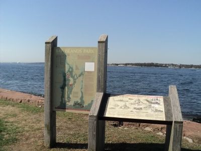
Other nearby markers. At least 8 other markers are within walking distance of this marker. Bay Islands Park (here, next to this marker); Fort Adams (about 300 feet away, measured in a direct line); Three Tiers of Firepower (about 500 feet away); Going Great Guns (about 500 feet away); The Irish Connection to Fort Adams (about 500 feet away); Defending Narragansett Bay (about 500 feet away); a different marker also named Defending Narragansett Bay (about 500 feet away); Returning Old Glory 2001 (about 500 feet away). Touch for a list and map of all markers in Newport.
More about this marker. Pictures of the eleven types of vessels listed above appear on the marker.
Credits. This page was last revised on June 16, 2016. It was originally submitted on October 17, 2011, by Bill Coughlin of Woodland Park, New Jersey. This page has been viewed 671 times since then and 14 times this year. Last updated on June 16, 2012, by Bryan Simmons of Attleboro, Massachusetts. Photos: 1, 2, 3, 4. submitted on October 17, 2011, by Bill Coughlin of Woodland Park, New Jersey. • Bill Pfingsten was the editor who published this page.


