Near Wildwood in Dade County, Georgia — The American South (South Atlantic)
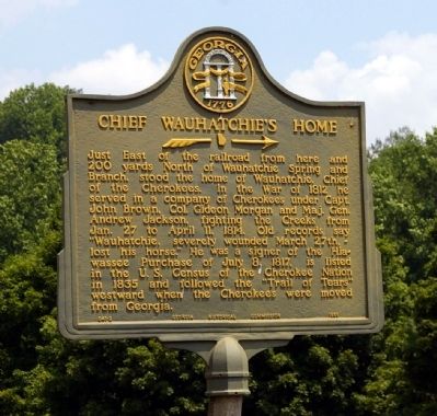
Chief Wauhatchie’s Home
Erected 1955 by Georgia Historical Commission. (Marker Number 041-2.)
Topics and series. This historical marker is listed in these topic lists: Native Americans • War of 1812. In addition, it is included in the Former U.S. Presidents: #07 Andrew Jackson, the Georgia Historical Society, and the Trail of Tears series lists. A significant historical date for this entry is March 27, 1906.
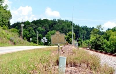
Location. 34° 58.5′ N, 85° 24.2′ W. Marker is near Wildwood, Georgia, in Dade County. Marker is on U.S. 11 near Georgia Route 299, on the right when traveling north. Marker is by the railroad tracks on the east side of US 11, immediately north of the intersection with GA Highway 299. Touch for map. Marker is in this post office area: Wildwood GA 30757, United States of America. Touch for directions.
Other nearby markers. At least 8 other markers are within 4 miles of this marker, measured as the crow flies. Tennessee AMVETS Veterans Memorial (approx. 1.3 miles away in Tennessee); Civil War in Tennessee (approx. 1.3 miles away in Tennessee); Carter Hall (approx. 1.7 miles away); The Redding House (approx. 2 miles away); Confederate Position, 1863 (approx. 2½ miles away in Tennessee); Federal Entrenchments (approx. 2.9 miles away in Tennessee); Greene's New York Brigade (approx. 2.9 miles away in Tennessee); See Seven States (approx. 3.2 miles away).
Credits. This page was last revised on August 25, 2019. It was originally submitted on July 23, 2008, by David Seibert of Sandy Springs, Georgia. This page has been viewed 3,225 times since then and 89 times this year. Last updated on July 30, 2012, by David Seibert of Sandy Springs, Georgia. Photos: 1. submitted on July 23, 2008, by David Seibert of Sandy Springs, Georgia. 2. submitted on July 28, 2012, by David Seibert of Sandy Springs, Georgia. • Kevin W. was the editor who published this page.

