Near Nancy in Pulaski County, Kentucky — The American South (East South Central)
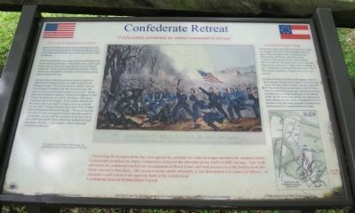
Confederate Retreat
"Every one for himself was the motto."
Much of the Confederate Army retreated through this area. They headed south along the Mill Springs Road toward their camps and fortifications just this side of the Cumberland River.
Mississippi and Tennessee regiments that had fought in the ravine and along the hotly contested fencerow on this side of the road also passed through this area as they left the battlefield. These men had fought long and hard. When finally they attempted to withdraw, Union infantry and artillery flanked their line.
Union cannons rolled into position on the Confederate right flank and quickly fired over fifty rounds into the Southern troops. This was too much to endure. Private David Scales of Company B, 20th Tennessee said, "We were overpowered and had to fight our way out." Seventeen-year-old Private James L. Cooper of Company C said, "It was anything but an orderly retirement. With much confusion, the retreat began. Every one for himself was the motto, and to get back to camp as soon as possible was the idea." Colonel Horatio Van Cleve of the 2nd Minnesota summarized the action saying: "The enemy having met with so warm a reception in front, and afterward being flanked ... on the right by a portion of our left, who by their well-directed fire drove them from behind their hiding places, leaving a large number of their dead and wounded on the field."
"I reluctantly permitted my entire command to retreat"
"Perceiving the fortunes of the day were against us, and that we could no longer maintain the unequal contest, I reluctantly permitted my entire command to retreat in the direction of our works at Mills Springs. Late in the afternoon my command reached our encampment at Beech Grove and took possession of the fortifications formerly erected at that place. Our position being wholly untenable, it was determined in a council of officers ... to abandon it and return to the opposite bank of the Cumberland." - Confederate General William Henry Carroll
A Grand and Gallant Charge
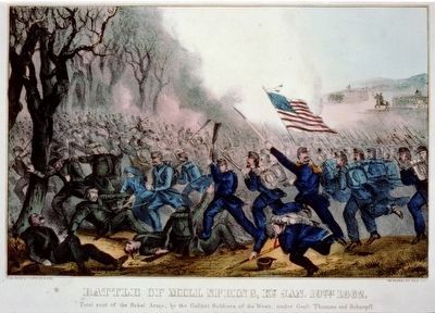
On the other side of the Mill Springs Road, a bayonet charge led by the 9th Ohio prompted the collapse of the left flank of the Confederate line. James Scully of Thomas' staff later wrote: "I witnessed the grand charge of the Gallant McCook with his Dutchman and a more splendid thing I never witnessed." Major John A. Brents of the 1st Kentucky concurred when he wrote, "The 9th Ohio made as gallant a charge as was ever witnessed."
Fearful of being outflanked and trapped, some of the Tennessee soldiers fled in panic. From this side of the road, just south of where you now stand, the 29th Tennessee fired into the flank of the 9th Ohio. This slowed the Union advance and allowed many Confederates to escape southward, A bit farther south, the 29th Tennessee and the 16th Alabama Infantry Regiments also made a stand before following their comrades in the general Confederate retreat toward the Cumberland River camps.
Erected by Mill Springs Battlefield Association.
Topics. This historical marker is listed in this topic list: War, US Civil.
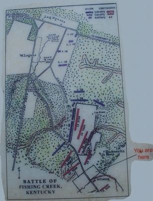
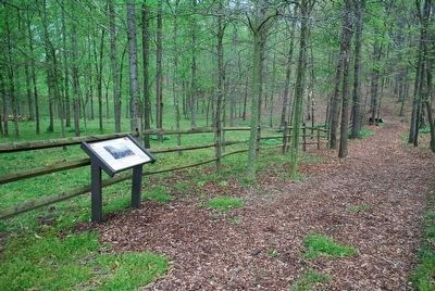
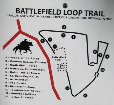
Location. 37° 3.267′ N, 84° 44.25′ W. Marker is near Nancy, Kentucky, in Pulaski County. Marker can be reached from Kentucky Route 235, 0.1 miles south of Kentucky Route 761, on the left when traveling south. This is Station 10 on the Battlefield Loop Trail from Tour Stop 2 - Zollicoffer Park. The location is in forest and was estimated using Bing Maps. Touch for map. Marker is in this post office area: Nancy KY 42544, United States of America. Touch for directions.
Other nearby markers. At least 8 other markers are within walking distance of this marker. The Union Advance (about 400 feet away, measured in a direct line); Victory! (about 500 feet away); Archaeology and the Mill Springs Battlefield (about 500 feet away); "Confederate Mass Grave" (about 600 feet away); The Ravine (about 600 feet away); Confederate Dead (about 600 feet away); Dawn of Battle (about 600 feet away); Confederate Mass Grave Memorial (about 600 feet away). Touch for a list and map of all markers in Nancy.
More about this marker. Marker has a battle map showing the location of the marker and a drawing published by Currier & Ives during the Civil War captioned: Battle of Mill Springs - Total Rout of the Rebel Army, by the Gallant Soldiers of the West, under Generals Thomas and Schoepff
Also see . . . Battle of Mills Spring. Wikipedia entry (Submitted on October 30, 2022, by Larry Gertner of New York, New York.)
Credits. This page was last revised on October 30, 2022. It was originally submitted on February 8, 2013, by David Graff of Halifax, Nova Scotia. This page has been viewed 416 times since then and 14 times this year. Photos: 1. submitted on February 8, 2013, by David Graff of Halifax, Nova Scotia. 2, 3. submitted on September 16, 2015, by Brandon Fletcher of Chattanooga, Tennessee. 4. submitted on February 8, 2013, by David Graff of Halifax, Nova Scotia. 5. submitted on September 16, 2015. • Craig Swain was the editor who published this page.
