Cusseta in Lee County, Alabama — The American South (East South Central)
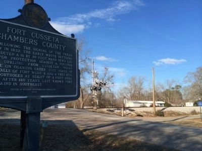
Fort Cusseta
Chambers County
Erected 1978 by the Historic Chattahoochee Commission.
Topics. This historical marker is listed in these topic lists: Forts and Castles • Native Americans • Settlements & Settlers. A significant historical year for this entry is 1832.
Location. 32° 47.075′ N, 85° 18.339′ W. Marker is in Cusseta, Alabama, in Lee County. Marker is at the intersection of Martin Luther King Drive (County Road 83) and County Road 82, on the right when traveling south on Martin Luther King Drive. Touch for map. Marker is in this post office area: Cusseta AL 36852, United States of America. Touch for directions.
Other nearby markers. At least 8 other markers are within 8 miles of this marker, measured as the crow flies. Pat Garrett and Billy the Kid / Pat Garrett, "The Man Who Shot Billy the Kid" (approx. 3.1 miles away); Shady Grove Christian Church (approx. 6.3 miles away); Bean's Mill (approx. 6.4 miles away); Providence Baptist Church (approx. 6.8 miles away); Fairfax First Christian Church (approx. 6.9 miles away); Fairfax Kindergarten (approx. 6.9 miles away); Armed Forces Tribute (approx. 7 miles away); Oak Bowery (approx. 8 miles away).
Also see . . . Fort Cusseta Historic Site. (Submitted on February 8, 2014, by Mark Hilton of Montgomery, Alabama.)
Credits. This page was last revised on June 16, 2016. It was originally submitted on February 8, 2014, by Mark Hilton of Montgomery, Alabama. This page has been viewed 1,531 times since then and 84 times this year. Photos: 1, 2, 3. submitted on February 8, 2014, by Mark Hilton of Montgomery, Alabama. • Bernard Fisher was the editor who published this page.


