Near Fairfax in Nicollet County, Minnesota — The American Midwest (Upper Plains)
Working Year-Round to Develop the Park
The New Deal and Fort Ridgely State Park
— United States Civilian Conservation Corps —
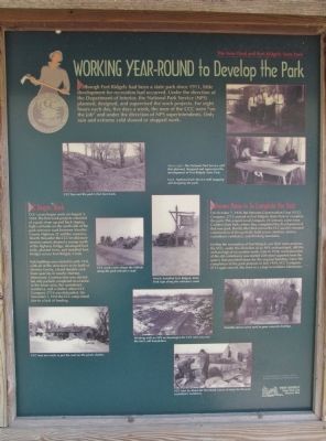
Although Fort Ridgely had been a state park since 1911, little development for recreation had occurred. Under the direction of the Department of Interior, the National Park Service (NPS) planned, designed, and supervised the work projects. For eight hours each day, five days a week, the men of the CCC were "on the job" and under the direction of NPS superintendents. Only rain and extreme cold slowed or stopped work.
CCC Begins Work
CCC crews began work on August 2, 1934. The first work projects consisted of a park clean up and back sloping high-cut banks on the north side of the park entrance road between Nicollet County Highway 21 and the cemetery. Shortly thereafter the CCC'ers did more erosion control, drained a swamp north of the highway bridge, developed foot trails, planted trees, and installed foot bridges across Fort Ridgely Creek.
Park buildings were started in early 1935 with all of the structures to be built of Morton Gneiss, a hard durable rock from quarries in nearby Morton, Minnesota. Construction was started but only partially completed on a latrine in the lower area, the custodian's residence, and a shelter when CCC Company 2712 was disbanded. On November 1, 1935 the CCC camp closed due to lack of funding.
Veterans Move In To Complete the Park
On October 7, 1936 the Veterans Conservation Corp (VCC) Company 2713 arrived in Fort Ridgely State Park to complete the park. This experienced company of veterans came from Camden State Park, where they completed the development of that new park. Shortly after their arrival the VCC quickly resumed construction of the partially-built picnic shelters, latrine, custodian's residence, and drinking fountains.
Feeling the restoration of Fort Ridgely was their main purpose, the VCC, under the direction of an NPS archaeologist, did the archaeological excavation work. Late in 1936, reconstruction of the old commissary was started with stone quarried from the quarry that provided stone for the original building. Upon the completion of the park projects in July 1939, VCC Company 2713 again moved, this time to a camp in northern Minnesota.
National Archives, Washington, D.C.
Fort Ridgely
State Park and
Historic Site
Topics and series. This historical marker is listed in these topic lists: Charity & Public Work • Parks & Recreational Areas
. In addition, it is included in the Civilian Conservation Corps (CCC) series list. A significant historical month for this entry is July 1939.
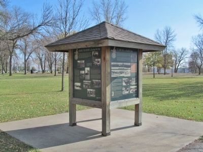
Location. 44° 27.166′ N, 94° 43.889′ W. Marker is near Fairfax, Minnesota, in Nicollet County. Marker can be reached from County Highway 30, 0.7 miles west of State Highway 4, on the right when traveling west. Marker is northwest of the cemetery in Fort Ridgely State Park; fee area – a Minnesota state park vehicle permit is required. Touch for map. Marker is in this post office area: Fairfax MN 55332, United States of America. Touch for directions.
Other nearby markers. At least 8 other markers are within walking distance of this marker. CCC Camp Life is a Healthful One (here, next to this marker); Fort Ridgely State Park's Buildings Today (here, next to this marker); A New Deal for Fort Ridgely State Park (here, next to this marker); Chief Mou-Zoo-Mau-Nee State Monument (about 400 feet away, measured in a direct line); Captain John S. Marsh State Monument (about 400 feet away); Eliza Müller State Monument (about 400 feet away); To the Memory of Hazen Mooers (about 400 feet away); Joseph LaFramboise - (about 500 feet away). Touch for a list and map of all markers in Fairfax.
More about this marker. photo captions:
• CCC lays out the park's first foot trails.
• Above right: The National
Park Serviced staff that planned, designed and supervised the development of Fort Ridgely State Park.
• Right: National Park Service staff mapping and designing the park.
• CCC work crews shape the hillside along the park entrance road.
• Newly installed Fort Ridgely State Park sign along the entrance road.
• VCC men are ready to put the roof on the picnic shelter.
• Working with an NPS archaeologist the VCC men uncover the fort's old foundation.
• Portable mixers were used to pour concrete footings.
• VCC men lay down the first finish course of stone for the park custodian's residence.
Also see . . . Fort Ridgely State Park. Minnesota Department of Natural Resources. (Submitted on February 19, 2014.)
Credits. This page was last revised on December 15, 2020. It was originally submitted on February 19, 2014, by Keith L of Wisconsin Rapids, Wisconsin. This page has been viewed 443 times since then and 15 times this year. Photos: 1, 2, 3. submitted on February 19, 2014, by Keith L of Wisconsin Rapids, Wisconsin.


